November 14, 2007
The Japan Agency for Marine-Earth Science and Technology
3D Geological Structure Analysis below the sea-floor at Sea of Kumano off Kii Peninsula
Unraveling Great Tsunami Genesis
1. Abstract
Gregory Moore, Asahiko Taira and Shin’ichi Kuramoto at the Japan Agency for Marine-Earth Science and Technology (JAMSTEC; Mr. Yasuhiro Kato, President) have clarified 3D geological structure under the sea-floor by analyzing data obtained from 3D seismic reflection survey conducted at Sea of Kumano off Kii Peninsula in April through May 2006 (refer to our press release on April 6, 2006). This analysis showed Megasplay fault derived from plate boundary is the source of the great tsunamis.
This result will be published on webpage of the USA science magazine, “Science” on November 16.
2.Background
The fundamental cause of Tsunami is sudden vertical change of bathymetric feature. It is considered to be induced by fault activities from plate boundary to near the sea-floor. At Nankai Trough accretionary prism, Megasplay fault derived from boundary fault between subducting plate (Philippine Sea Plate) and upper plate (Eurasia Plate) had been discovered. And the idea that the Megasplay fault induces the change of bathymetric feature and resulted in generation of tsunami has been controversial.
3.Details
- (1)Method
- At the Sea of Kumano, 3D seismic reflection survey was implemented to create 3D visualization of Megasplay fault, as a preliminary survey for Nankai Trough scientific drilling by the Deep-sea Drilling Vessel Chikyu.
- (2)Analysis result (Refer to Fig.1~Fig.3)
-
Based on the analysis of 3D geological structure acquired from (1), the followings became clear.
a) Megasplay fault is derived from the plate boundary fault.
b) Megasplay fault cut through the old fault which is forming accretionary prism.
c) Structure of Megasplay fault and tracks of large-scale landslide on the sea-floor suggest that this splay fault is still active and new fault evolves landward (north) direction.
d) The Megasplay fault gradually evolves in higher angle from seaward (south) to landward and it changes bathymetric feature more vertically.
4.Discussion
These analyses clarified that the activities of Megasplay fault in Sea of Kumano is the key for bathymetric feature changes. The Megasplay fault has been derived from the plate boundary. It is very active with evidence of recent activities. Therefore, it is considered that the Megasplay fault is still active and this is the one that caused historical tsunamis such as the tsunami of Tonankai earthquake in 1944 (magnitude 8.1)
(*1) Nankai Trough Accretionary Prism
Nankai Trough derived from Suruga Bay runs to off the coast of Tokai ~ Kii Peninsula ~ Shikoku ~ Kyushu, where the Philippine Sea Plate subducting under the west-south Japanese archipelago, (Usually, ‘trough’ means long thin ditch on the sea-floor, but here it means ‘trench’: which length is approximately 770km). Along with this plate subduction, geological phenomenon that sediment on the plate is taken off and added to the plate on land side is occurs at this area in the ocean, such newly formed geological sediments are called “accretionary prism”. It is recognized that its progress is very important as a basic process of orogenesis, and also the front line research is conducted as the seismogenesis zone.
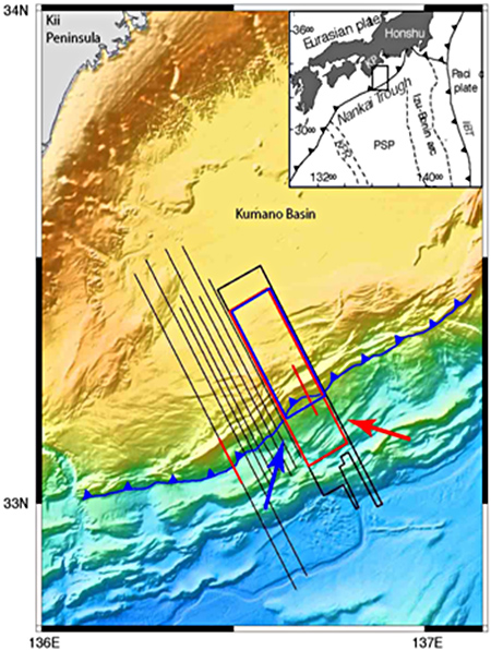
Fig.1 Survey sea area
Embedded upper right shows location of each plate. The area surrounded by black line is 3D Seismic Reflection Survey area. The area of Fig.2 is surrounded by red line. Red arrow indicates visual direction of Fig.2. The red straight line is the location of Fig.3. Blue line with hachure indicates the place where Megasplay fault appears on the sea-floor.
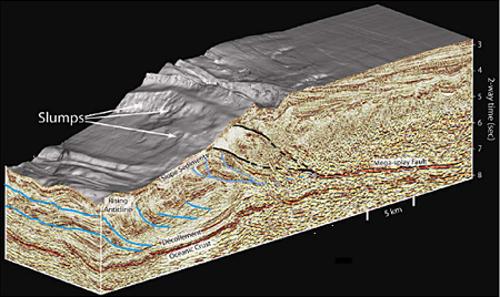
Fig.2
Megasplay fault derived from the plate boundary goes through up to the sea-floor, brings to significant change on bathymetric feature including underwater landslide. This splay fault is considered to be the source of the historical tsunamis. (left: trench side, right: land side)
* Décollement:
Horizontal slip surface developed in association with subduction of oceanic plate.
*Vertical scale “2-way time (sec.)”:
It indicates time required for acoustic wave to reflect from the sea-floor and back to the sea surface. This is the typical method to represent reflection survey record. Depth can be described as vertical scale when precise geological velocity structure is acquired.
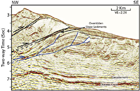
Fig.3
Megasplay fault cuts through the overridden slope sediment and continues up to near the sea-floor. The fault activity seems relatively new since it cuts through old fault of accretionary prism (that indicates the action is younger) and also cut the new sediment close to the sea-floor.
Contacts:
- (For the Research)
- Mr. Shin’ichi Kuramoto, e-mail: cdex@jamstec.go.jp
Group Leader, Program Operation Group, IODP Department
The Center for Deep Earth Exploration (CDEX)
Japan Agency for Marine-Earth Science and Technology
- (For Publication)
- Mr. Shinji Oshima, e-mail: press@jamstec.go.jp
Manager, Planning Department Press Office
Japan Agency for Marine-Earth Science and Technology