December 14, 2007
The Japan Agency for Marine-Earth Science and Technology
Deep-sea Cruising AUV "Urashima" Succeeds
Detail mapping of hydrothermal field in Okinawa Trough
1.Outline
The Japan Agency for Marine-Earth Science and Technology (JAMSTEC: Mr. Yasuhiro Kato, President) has conducted technical test of the Deep-sea Cruising AUV "Urashima"*1 (Pic.1) for precise research of hydrothermal activity*2 at Iheya North (Fig.1) in Okinawa Trough.
The precise research of this area shall contribute to the study of material circulation and submarine resources, since the area is known as dynamic thermal activity. However, to obtain high-resolution data uniformly from rough bathymetric feature of this area, measurements should be done by an instrument which can keep uniform height from the seafloor.)
As a consequence of improving Urashima to conform to this rough bathymetry, we verified that Urashima could cruise controlling at constant altitude from the seafloor on the engineering test. We have succeeded to create high-resolution bathymetry map by enhancing measurement accuracy of the multi-beam echo sounder*3 and inertial navigating system.
The detailed bathymetry map (Fig.2) acquired by this survey revealed formation and distribution of hydrothermal mound and chimneys in the area with unprecedented detail. Side-scan sonar*4 visualized the hydrothermal flow from the vent as continuous acoustic reflection images (Fig.3).
2.Description
The precise research has conducted at Iheya North of Okinawa Trough (Fig.1: 1,000m depth of water, approximately 180km northwest off Okinawa main island) from May 6th to May 18th in 2007, utilized Deep-sea Cruising AUV "Urashima". Measurement has made by multi-beam echo-sounder and side-scan sonar on Urashima keeping 80m stable height from the seafloor. (Fig.4)
Result:
1) High-accuracy bathymetry map
Bathymetry map with vertical and horizontal resolutions of 10cm and 60cm respectively was acquired from combination of coordinate values of multi-beam echo-sounder and side-scan sonar system. On sounding conducted by vessels until now, it is inevitable that deeper the water, lower the precision, so that it has been impossible to capture detailed bathymetry such as distribution of hydrothermal mounds and group of chimneys. Urashima has made it possible to create detailed bathymetry map using its advanced cruising technology.
2)Continuous acoustic reflection images
Many possible hydrothermal plumes*5 were identified in the ocean bottom layer up to 80m of continuous acoustic reflection images created on the both water columns by data obtained from side-scan sonar. The area where acoustic reflection images were obtained matched to the locations that active hydrothermal emissions were identified on the previous survey in Iheya North knoll. The area also matched to the location of hydrothermal vents in the high-precision bathymetry map obtained this time. And equipped physicochemical sensor*6 indicated numeric anomaly (increased temperature: Fig.5) affected by hydrothermal activity only at where acoustic reflection images had been obtained.
3.Significance
High performance of Urashima has been confirmed on this engineering cruise. Accuracy improvement is expected for various deep-sea scientific researches and studies utilizing Urashima, including basic research of hydrothermal deposit, and research of marine active faults distribution and activity factor. Additionally, it is expected to contribute to preliminary survey for deep-sea drilling of the Integrated Ocean Drilling Program (IODP).
- *1
- Deep-sea Cruising AUV Urashima:
"Urashima", an large class autonomous underwater vehicle (AUV) is being developed with high technology computers, navigation systems and power supply for research of rough or icebound ocean, and areas near active volcanoes, where the support ship can not get close. In February 2005, "Urashima" has succeeded to achieve the world record for continuous cruise (317km) with closed-cycle fuel cells on-board. From 2006, enhanced the navigation control system and equipped with deep-sea research devices, "Urashima" has been conducting technical test for precise research on the deep-sea bottom. - *2
- hydrothermal activity:
Hydrothermal activity indicates thermal emission out of Earth interior and it is related to whole mantle dynamics. Seawater infiltrated into the subsurface is to be heated by magma activity and released out of vent on the seafloor as thermal emission dissolving many kinds of materials after experiencing thermal reaction process. In thermal emission there are gas component such as carbon dioxide and methane, rocks and minerals component melted from oceanic crust, part of those are used for marine biological production. It is estimated that flow rate of seawater circulation and hydrothermal circulation is almost the same as flow rate of rivers flowing into the ocean. On marine ecosystem, researches are conducted such as distribution of specific hydrothermal dependent community and impact of chemical component on marine biological production. - *3
- multi-beam acoustic sounder:
Bathymetry map is created by echo sounder; the system equipped with "Urashima" this time is much more precise than previous systems. ROVs (Remotely Operated Vehicle) or AUVs are possible to create higher-precision bathymetry map than vessels on water, since they can equip ultra high frequency acoustic instruments with multi acoustic beams of high resolution while short detection range, by getting close to seafloor. The map acquired this time shows bathymetric feature with vertical and horizontal resolutions of 10cm and 60cm respectively. - *4
- side-scan sonar:
A transducer equipped on each side of "Urashima" emits ultrasound waves repeatedly and receives reflected (scattered) sound waves (echo) from the seafloor while cruising. Scattering intensity of ultrasound wave varies with bathymetric feature and bottom properties, so that by utilizing the side-scan sonar, acoustic images can be acquired expressing detail seafloor images acoustically. - *5
- hydrothermal plume
Hydrothermal plume is water mass of unique physicochemical nature formed by hydrothermal emission from the seafloor mixed with seawater around. Since its composition reflects hydrothermal emission, subsurface mineral composition affects it strongly. As for scale of emission, it varies with magma activity under the seafloor and geological structure of ocean crust. - *6
- physicochemical sensor (developed by Central Research Institute of Electric Power Industry):
Chemical sensor using ion-sensitive field-effect transistor (ISFET) is used to measure pH and partial pressure of carbon dioxide. Since it responds quickly, it is applicable to ROV or AUV that travels at high-speed.
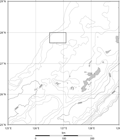
- Fig.1
- Survey Area (
 indicates Iheya hydrothermal field)
Hydrothermal activity in North Knoll of Iheya ridge in Okinawa Trough(North Latitude 27°47', East Longitude 126°53', Water depth 1000m) have been continuously studied with enthusiasm mainly by geosciences and microbiology since its discovery in 1995. There are up to 300°C hydrothermal emissions there.
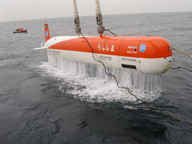
- Pic.1
- Retrieval of the Deep-sea Cruising AUV "Urashima" by support ship(This photograph was taken at the past test cruise)
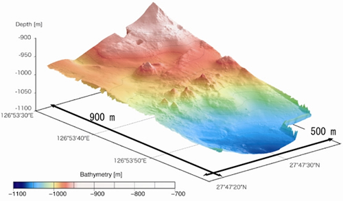
- Fig.2 (a).
- Bathymetry map of Iheya North hydrothermal field (3D)
High-precision 3D bathymetry map created by data acquired from multi-beam echo sounder on "Urashima"
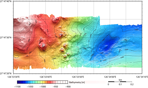
- Fig.2 (b).
- Bathymetry map of Iheya North hydrothermal field (2D) High-precision 2D bathymetry map created by data acquired from multi-beam echo sounder on "Urashima"
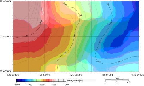
- Fig.2 (c).
- Bathymetry map of Iheya North hydrothermal field (Obtained from ship)
Bathymetry map created by data acquired from multi-beam echo sounder on the research vessel.
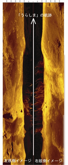
- Fig.3.
- Continuous acoustic scattering image including water columns of Iheya North hydrothermal field
Colors indicate reflection intensity. Dark means weak and light mean strong. Image of seawater reflection is dark area in the middle and high intensity part detected there is considered as hydrothermal plume.
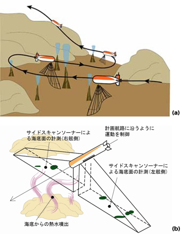
- Fig.4.
- Image of the precise research of hydrothermal activity on the seafloor
(a)Research conducted at hydrothermal field at an elevation of 80m from the complex bathymetric feature
(b)Research conducted by side-scan sonar continuously obtained acoustic reflection images from both port side and starboard side.
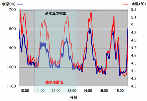
- Fig.5.
- Relationship between water depth and temperature data at Iheya North hydrothermal field obtained by physicochemical sensor on "Urashima".
Around active area, temperature is high even at great depth of water.
Contacts:
- (For "Urashima")
-
Dr. Satoshi Tsukioka,
Sub Leader, Marine Engineering Group, Department of Applied Ocean Engineering, Marine Technology Center (MARITEC),
Japan Agency for Marine-Earth Science and Technology - (For Publication)
-
Mr. Shinji Oshima, e-mail: press@jamstec.go.jp
Manager, Planning Department Press Office
Japan Agency for Marine-Earth Science and Technology