April 20, 2009
Japan Agency for Marine-Earth Science and Technology
Deep-Sea Drilling Vessel CHIKYU
2009 IODP Nankai Trough Seismogenic Zone Experiment (NanTroSEIZE)
The Deep-sea Drilling Vessel CHIKYU, operated by the Japan Agency for Marine-Earth Science and Technology (JAMSTEC: Yasuhiro Kato, President), departed the Port of Kobe on February 15, 2009 and completed all functional tests for her replaced azimuth thruster (a 360 degree swiveling propellers to maintain the ships position during drilling operations). The CHIKYU is now under operational training in Suruga Bay and in the Kumano Basin.
Following the training, the CHIKYU will call at the Port of Shingu in Wakayama Prefecture in early May to load materials before setting sail on May 10 to resume her mission in the IODP(*1) expeditions for the Nankai Trough Seismogenic Zone Experiment (NanTroSEIZE)(*2) in Kumano Basin off the Kii Peninsula(Fig.1).
1.CHIKYUs schedule
| Training on drilling operations in Suruga Bay | Until around May 4 | |
| Material loading at Port of Shingu | Around May 6 | |
| Sail from Port of Shingu | Around May 10 | |
| IODP Expedition 319 (Site NT2-11, Riser drilling) | Mid-May to End of July | |
| IODP Expedition 319 (Site NT2-01, Riserless drilling) | Early August to End of August | |
| IODP Expedition 322 (Site NT1-07, Riserless drilling) | Early September to Early October |
2.Expedition Overview and Co-Chief Scientists
The NanTroSEIZE Stage 2 expeditions in FY2009 involve drillings deep into the upper portion of the seismogenic zone responsible for great earthquakes to characterize geological structures and state. The borehole will be used for the future installation of the Long-Term Borehole Monitoring Systems (LTBMS) that will serve to monitor earthquake generation processes. The expeditions will also collect data on the composition, architecture and geophysical properties of pre-subduction sediments before they are subducted to the seimogenic zone. The outline of each expedition is as follows.
(1) IODP NanTroSEIZE Stage 2 Expedition 319Site NT2-11 (Fig.1, 2), water depth:2,061m, maximum drill depth: approx. 1,600m below the seafloor
This expedition aims to drill into and sample the upper most portion of the great earthquake zone in the Kumano Basin, using riser drilling(*3) and geophysical logging(*4). Data will be collected on the lithostratigraphy, structure and physical properties of the formation. Rock samples will also be collected. The borehole will be utilized for a long-term monitoring of the downhole conditions. As a part of geophysical logging, an experiment to accurately profile the geological structure of the plate interface and the accretionary prism is planned, using about 20 seismometers being lowered from the CHIKYU into the borehole and by use of elastic waves (Vertical Seismic Profiling (VSP)) (Fig. 3). The elastic waves will be fired from an air-gun towed by the JAMSTECs research vessel KAIREI. The drilling by the CHIKYU in this expedition will mark the worlds first scientific riser drilling.
Site NT2-01 (Fig.1, 2), water depth:2,535m, maximum drill depth: approx. 525m below the seafloor
The expedition will drill through the shallow portion of the megasplay fault branching from the seismogenic zone, using riserless drilling. Data will be obtained from downhole geophysical logging, on lithostratigraphy, architecture and physical properties. The borehole will be utilized for the Long-Term Borehole Monitoring System (LBM) scheduled to install in the 2010 expedition.
Co-chief Scientists:
Eiichiro Araki (Japan Agency for Marine-Earth Science and Technology)
Timothy Byrne (University of Connecticut, U.S.)
Lisa McNeill (University of Southampton, U.K.)
Demian Saffer (Pennsylvania State University, U.S.)
(2) IODP NanTroSEIZE Stage 2 Expedition 322Site NT1-07 (Fig.1, 2), water depth:4,062m, maximum drill depth: approx. 1,200m below the seafloor
This expedition conducts riserless drillings to investigate geological input materials before they are entering the seismogenic zone, by characterizing the composition, architecture and geophysical properties of sediments for all layers. Core sampling will also be conducted.
Co-chief Scientists:
Michael Underwood (University of Missouri, U.S.)
Saneatsu Saito (Japan Agency for Marine-Earth Science and Technology)
During the above expeditions, more than 50 researchers from the IODP participating countries will be on board the CHIKYU. The above plans, including the maximum drill depth, may change in accordance with the progress in drilling operations and weather.
*1. Integrated Ocean Drilling Program (IODP)
The Integrated Ocean Drilling Program (IODP) is an international marine research drilling program dedicated to advancing scientific understanding of Earth by monitoring and sampling subseafloor environments. Through multiple platforms, preeminent scientists explore IODP principal themes: the deep biosphere, environmental change, and solid earth cycles. IODP has started since October 2003 funded jointly by the Ministry of Education, Culture, Sports, Science and Technology of Japan and the U.S. National Science Foundation; with additional support provided by the European Consortium of Ocean Research Drilling; the People's Republic of China, Ministry of Science and Technology, and the Republic of Korea through the Korea Institute of Geoscience and Mineral Resources. IODP now has 21 member countries.
*2. Nankai Trough Seismogenic Zone Experiment (NanTroSEIZE)
(1) Background
The Nankai Trough is a subduction zone located southwest of Japan, stretching from off the coast of Tokai region to Shikoku and Kyushu. It is the place where the Philippine Sea Plate slides beneath the Eurasian plate and is one of the most active earthquake zones on the planet. The Kumano Basin, off the Kii Peninsula, is a forearc basin of the Nankai Trough subduction zone. In this region, areas inferred to be the sources of great earthquakes including the 1944 Tonankai earthquake (identified by characteristics of coseismic slip), lie at depths of about 6,000 meters, which is very shallow compared to other plate boundaries in the world and is within the operational limits of riser drilling by the CHIKYU.
The Nankai Trough Seismogenic Zone Experiment is an ocean drilling project that drills in the plate boundary and the megasplay fault believed to have generated Tsunami. The experiment aims to shed light on the transition from aseismic to seismic slip within the plate boundary fault zone, as well as on the process of earthquake or Tsunami occurrences, by use of geological sampling (core sampling) and measurement of downhole conditions.
(2) Program overview
The NanTroSEIZE consists of four Stages. Drilling operations are to be conducted at several Sites in the Kumano Basin, off the Kii Peninsula, which are located along a line orthogonally crossing the Nankai trough (Fig.4).
Stage 1
Expeditions involved drillings in the shallow portions of the megasplay fault and plate boundary thrust. Data was gathered on characteristics of coseismic faults, including geologic distribution, deformation structure and state of stress. (Please refer to (3) for the results)
Stage 2
Expeditions will drill deep into the upper portion of the seismogenic zone of great earthquakes to unravel its geological structure and state. The borehole will be utilized for the future installation of observatory systems that will be used to monitor the processes of earthquake generation. The expedition will also characterize the composition, architecture and geophysical properties of pre-subduction sediments before they are transported to the seismogenic zone.
Stage 3
Expeditions will focus on ultra-deep drilling that can reach the seismogenic zone, on which great earthquakes have repeatedly occurred. Operations include direct core sampling from the seismogenic zone to understand the seismogenic mechanism from a material science point of view.
Stage 4
In this Stage, long-term observatory systems will be deployed in the ultra-deep boreholes. Ultimate future goals include that the NanTroSEIZE boreholes could be connected to an underwater seismic monitoring network so that real-time data from earthquake occurring sites could be made available.
(3) Achievements in Stage 1 expeditions (Implemented from September 21, 2007 to February 5, 2008)
In 2007, the Deep-Sea Drilling Vessel CHIKYU embarked on her first scientific expedition, the IODP Nankai Trough Seismogenic Zone Experiment Stage 1, in the Kumano Basin off the Kii Peninsula. During three expeditions in this Stage, the CHIKYU carried out drilling at 33 holes (a total of 12,800 meters in length) which includes geophysical measurements at five Sites using Logging While Drilling (LWD) and core sampling at six Sites (a total of 3,400 meters in length). Achievements include the understanding of stress field of the shallower portion of the seismogenic zone, discovery of methane hydrates and geological evidence of past fault activities.
*3. Riser drilling
The drilling technology using marine riser pipe which connects the CHIKYU and the seafloor, guides the drill pipe and circulate drilling fluid inside the borehole. Combined with the use of a blow out preventer (BOP), it can maintain pressure balance within the borehole and prevent it from collapsing, allowing safer and deeper drilling.
*4. Geophysical logging
Geophysical logging is a method to continuously measure geophysical properties of geological formation by positioning sensors within the borehole.
In the Stage 2 expeditions, three logging techniques - wireline logging (WL), Logging While Drilling (LWD) and Measurement While Drilling (MWD) - are planned to be used, in accordance with the purpose of the borehole.
Wireline logging is a technique that employs a cable to lower sensors into the boreholes to measure geophysical properties. In riser drilling operations, sensors are directly conveyed down the borehole; while in riserless drilling operations, they are lowered inside the drill pipe that descends from the CHIKYU.
LWD is a technique to measure geological formation properties at a site while drilling, by attaching a physical measurement sensor near the drill bit. With this technique, core sampling is not possible; however, through continuous in-situ monitoring during drilling, geological data at the drilling site can be obtained in real time. The LWD can provide valuable data not only for science but also for safety monitoring and risk mitigation of the boreholes, which can be useful in the following core sampling operations. As such, LWD is a very effective tool in drilling sites with complex geological structure, especially in the Nankai trough. Data expected to be obtained by logging are resistivity, formation density, porosity, velocity of formation, natural gamma ray, fluid pressure and borehole gradient.
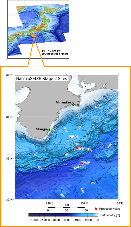
Figure 1: Survey area
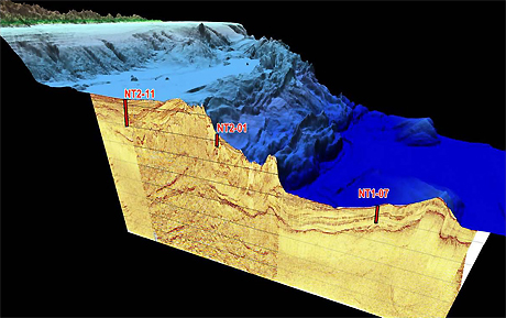
Figure 2: 3D Image of sea floor topography and subsea floor structure at drilling sites
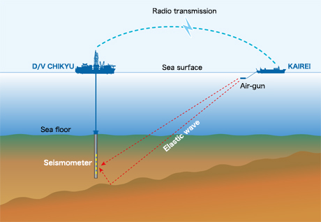
Figure 3: Schematic sketch of VSP at NT2-11
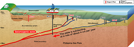
Figure 4: NanTroSEIZE Drilling Plan
Contacts:
- (For the expeditions)
-
TakeoTanaka, e-mail: cdex@jamstec.go.jp
Manager, Planning and Coordination Department
Center for Deep Earth Exploration (CDEX)
Japan Agency for Marine-Earth Science and Technology
- (For Publication)
-
Noriyuki Murata, e-mail: press@jamstec.go.jp
Manager, Planning Department Press Office
Japan Agency for Marine-Earth Science and Technology