
September 3, 2009
Japan Agency for Marine-Earth Science and Technology
Integrated Ocean Drilling Program (IODP)
Nankai Trough Seismogenic Zone Experiment (NanTroSEIZE)
Deep-Sea Drilling Vessel CHIKYU Successfully Completes
Expedition 319
1. Overview
The Japan Agency for Marine-Earth Science and Technology (JAMSTEC: Yasuhiro Kato, President), is pleased to announce that the Deep-sea Drilling Vessel CHIKYU, operated by JAMSTEC, has completed IODP (*1) Expedition 319 for Stage 2 of the Nankai Trough Seismogenic Zone Experiment (NanTroSEIZE) (*2), as of August 31, including drilling operations at the Kumano Basin, off the Kii Peninsula that began May 10th, 2009.
2. Expedition 319 overview
Expedition 319 marked the first riser drilling (*3) in the history of ocean drilling program. At the first site, it drilled into the plate above the seismogenic zone responsible for great earthquakes, for a period of 83 consecutive days between May 10th and July 31st. The operations resulted in a collection of geological samples from a depth of about more than 1,500 meters beneath the sea floor, as well as geophysical data from a variety of logging.
In the following operations at the second and third sites, riserless drilling was carried out from August 1st to 31st, which penetrated the shallower portion of the meagasplay fault branching from the seismogenic zone. Logging While Drilling (LWD) (*4) was employed to collect geophysical information. Following the drilling, scientists installed devices to continuously monitor conditions in the fault zone, and prepare the borehole for future installation of more sophisticated sensors.
The expedition was led by four co-chief scientists: Eiichiro Araki, Research Scientist of JAMSTEC; Timothy Byrne, Professor of the University of Connecticut, USA; Lisa McNeill of the University of Southampton, UK; and Demian Saffer, Associate Professor of Geosciences at The Pennsylvania State University, and was joined by twenty six scientists from eight countries.
3. Primary results
Expedition 319 conducted drilling operations at three drill sites in the Nankai Trough: the upper most portion of the seismogenic zone for great earthquakes (Site C0009, NT2-11), the shallower portion of the megasplay fault branching from the seismogenic zone (Site C0010, NT2-01), and the sediment zone before being subducted to the seismogenic zone (Site C0011, NT1-07)(Fig. 1). The operations at Site C0009 saw a collection of a total 57.87 meters of core sample (a cylindrical geological sample) from depths between 1,510 and 1,593.9 meters. Geophysical data were also successfully obtained by LWD operations at Sites C0010 and C0011. The summary of operations and analyses at each site is shown in Table 1.
The summary of operations and achievements
| 1. | At the first site C0009, scientists conducted the first riser drilling in the IODP history and successfully drilled down to a depth of 1,603.7 meters beneath the sea floor. A variety of new measurements taking advantage of riser drilling capability were also conducted. All of the planned science and engineering objectives at this site were completed, including drilling into the upper portion of the seismogenic zone, sampling of cores, and casing the borehole for protection. Geological details along the plate boundary fault below the drill hole were also obtained, using Vertical Seismic Profiling (VSP). Following these operations, scientists made preparations for the future installation of a Long-Term Borehole Monitoring System (LTBMS).
|
||||||||||
| 2. | At a second borehole (Site C0010), drilling crossed one of the major faults in the plate boundary, known as the megasplay fault, at a depth of about 400 meters below the seafloor. This fault is a prime candidate for tsunami generation, and may have slipped in historical great earthquakes. During the drilling operation, scientists documented rock physical properties by LWD and gain information about stresses in the formation. The borehole was then cased and utilized for observatory operations for the future long-term borehole monitoring. These included lowering of test instruments, as well as emplacement of a temporary sensor package that will monitor conditions in the fault zone in the next few years. |
4. Future schedule
The CHIKYU is now berthed at the Port of Yokkaichi for the rotation of science parties and loading of materials. It is scheduled to set sail on September 4th to begin the following IODP Expedition 322, which will conduct coring operation by riserless drilling at the Site C0011 until around October 10th. Expedition 322 is to be led by Co-Chief Scientists, Prof. Michael Underwood, the University of Missouri, and Dr. Saneatsu Saito, the Institute for Research on Earth Evolution of JAMSTEC, joined by twenty-seven scientists from nine countries. Operations will include core sampling and logging for all layers in the formation, with an aim to better understand the initial state of geological input materials before they are entering the seismogenic zone.
* The above schedule is subject to change depending on the progress of drilling operation and weather.
*1. The Integrated Ocean Drilling Program (IODP) is an international marine research drilling program dedicated to advancing scientific understanding of Earth by monitoring, sampling, and instrumenting subseafloor environments. Through multiple platforms, preeminent scientists explore IODP principal themes: the deep biosphere, environmental change, and solid Earth cycles. IODP has operated since October 2003, funded jointly by the Japan Ministry of Education, Culture, Sports, Science and Technology and the U.S. National Science Foundation. Additional support is provided by the 17-member European Consortium of Ocean Research Drilling, the People's Republic of China, the Republic of Korea, Australia, India, and New Zealand.
*2. Nankai Trough Seismogenic Zone Experiment (NanTroSEIZE)
The Nankai Trough is a subduction zone located southwest of Japan, stretching from off the coast of Tokai region to Shikoku. It is a place where the Philippine Sea Plate slides beneath the Eurasian plate and is one of the most active earthquake zones on the planet. The Kumano Basin, off the Kii Peninsula, is a forearc basin of the Nankai Trough subduction zone. The area inferred to be responsible for great earthquakes including the 1944 Tonankai earthquake, is located at a depth of about 6,000 meters below the seafloor, much shallower than those of other plate boundaries in the world, and is within the operational limits of riser drilling by the CHIKYU.
The Nankai Trough Seismogenic Zone Experiment is an ocean drilling project that drills in the plate boundary fault and the megasplay fault believed to have generated Tsunami. It aims to gain insight into the transition from aseismic to seismic slip within the plate boundary fault zone, as well as the processes of earthquake or Tsunami occurrences, by collecting geological samples (core samples) and measuring downhole conditions.
The drilling project consists of four stages in all, planned to conduct drilling operations at several sites located along a line orthogonally crossing the Kumano Basin. The first stage was carried out between September 21st, 2007 and February 5th, 2008.
*3. Riser drilling involves a large marine riser pipe that connects the CHIKYU and the seafloor. The riser pipe guides the drill pipe as it reenters the well. Drilling fluid is pumped up and down between the riser pipe and the drill pipe. Fluid circulation and use of the blow-out preventer (BOP) help maintain pressure balance within the borehole and prevent it from collapsing, enabling safer and deeper drilling.
*4. Logging While Drilling (LWD) is a technique to measure formation properties while drilling, by use of physical measurement sensors attached near the drill bit. With this technique, core is not sampled; however, geophysical data at the drill bit can be obtained almost in real time through continuous in-situ measurement during drilling. LWD can provide valuable data not only for science but also for safety monitoring and risk mitigation of the boreholes which can be useful in the following core sampling operations. It is a very effective tool for drilling into a complex geological formation, especially the ones observed in the Nankai Trough.
Data obtained by the logging include resistivity, formation density, porosity, velocity of formation, natural gamma ray, fluid pressure and borehole gradient.
| Proposed Site (*1) |
NT2-11 | NT2-01 | NT1-07 | |
|---|---|---|---|---|
| Hole Number (*2) |
C0009 | C0010 | C0011 | |
| Hole Name | A | A | A | |
| Drilling Method |
Riser drilling | Riserless drilling | Riserless drilling | |
| Location | Latitude | 33°27.5’ N | 33°12.6’ N | 32°49.7’ N |
| Longitude | 136°32.1’ E | 136°41.2’ E | 136°52.9’ E | |
| Operating Days |
83.0 | 24.5 | 6.5 | |
| Water Depth (m) |
2054.0 | 2523.7 | 4049.0 | |
| Total Depth (mbsf*) |
1603.7 | 555.0 | 952.2 | |
| Operation |
|
|
|
|
| Measurement and Analysis |
|
|
|
|
* mbsf: meters below the seafloor
(*1) Proposed Site: drill site proposed prior to drilling operations
(*2) Hole Number: borehole number named for IODP after drilling
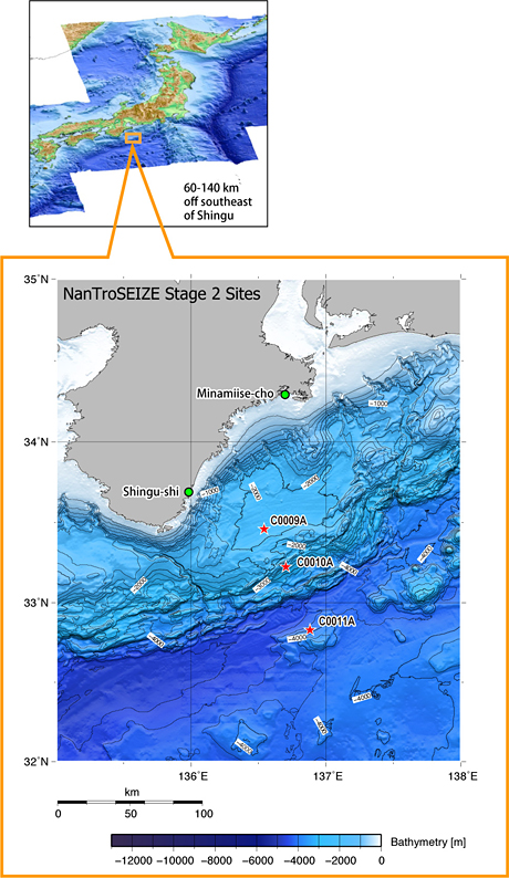
Figure 1: Survey area
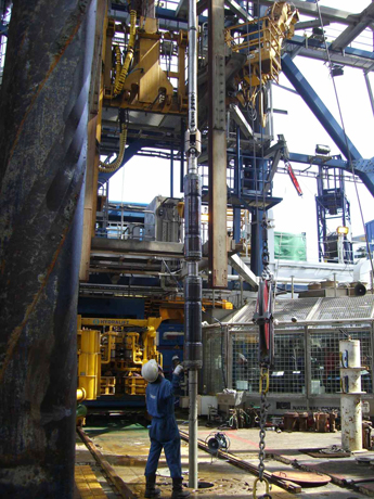
Photo 1: Lowering the tool to measure stress and pore fluid pressure in the subsurface
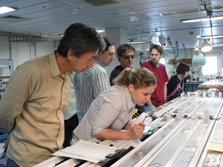
Photo 2: International group of scientists examine cores in the shipboard laboratory
Contacts:
- Japan Agency for Marine-Earth Science and Technology
(For the expeditions) -
Yasuo Yamada, e-mail: cdex@jamstec.go.jp
Manager, Planning and Coordination Department
Center for Deep Earth Exploration (CDEX)
- (For Publication)
-
Toru Nakamura, e-mail: press@jamstec.go.jp
Manager, Planning Department Press Office