June 8, 2010
Japan Agency for Marine-Earth Science and Technology
IODP Expeditions 2010 Schedule
Deep-Sea Drilling Vessel CHIKYU
The deep-sea drilling vessel Chikyu, operated by the Japan Agency for Marine-Earth Science and Technology (JAMSTEC), is now under periodic maintenance after five years of operation, which commenced on April 1st and is scheduled for completion on June 10th, 2010. Following this, the Chikyu will resume scientific expeditions for the Integrated Ocean Drilling Program (IODP) (*1) during the 2010 season as scheduled below.
Expedition schedule for CHIKYU
| 15 July - 8 August 2010 | IODP Expedition 326 - Nankai Trough Seismogenic Zone Experiment (NanTroSEIZE)(*2) Stage 3: Plate Boundary Deep Riser -1 |
| 1 September - 3 October 2010 | IODP Expedition 331 - DEEP HOT BIOSPHERE |
| 25 October - 12 December 2010 | IODP Expedition 332 - NanTroSEIZE Stage 2: Riserless Observatory-2 |
| 13 December 2010 - 10 January 2011 | IODP Expedition 333 - NanTroSEIZE Stage 2: Inputs Coring -2 & Heat Flow |
Expeditions Overview
(1) IODP Expedition 326 :NanTroSEIZE Stage 3: Plate Boundary Deep Riser-1
1) Science objectives:
The NanTroSEIZE Stage 3 operations will begin the main borehole for ultra-deep drilling (*3) and coring of the plate boundary (*) seismogenic zone, eventually expected to reach an unprecedented 7 km below the seafloor, in an attempt to shed light on the seismic mechanism responsible for large earthquakes. The primary goal of this expedition is to prepare the borehole for future ultra-deep riser drilling.
*The plate boundary is a place where an oceanic plate slides beneath another plate, expected to be at depths of 6,000 to 7,000meters below the seafloor (mbsf) in the study area.
2) Primary operation plan:
The expedition is scheduled for 24 days, from July 15 to August 8, 2010 at the drill-site C0002 (Fig. 1, 2 and 3). It plans to riser drill into the upper plate boundary and prepare the hole for future ultra-deep riser deployment, Operations also include the installation and casing of the wellhead.
3) Co-Chief Project Scientists:
TBA
(2) IODP Expedition 331- DEEP HOT BIOSPHERE
1) Science objectives:
The goal of Expedition 331 is to directly sample hydrothermally active mounds in the Okinawa Trough to obtain evidence for microbial communities. This includes variations in biomass and species diversity, as well as the function and impact of such active subseafloor microbial ecosystems underneath the hydrothermal vents. The results are expected, not only to provide clues to the role of a subsurface biosphere left untouched deep under the sea, but also to help understand the mechanism of microbial methane generation and gas transport in seafloor sediments. The expedition also expects to reveal the relationship between the extent of subseafloor microbial communities and methane commonly found at high concentration in the hydrothermal fluids, and the formation of hydrothermal mineral deposits.
2) Primary operation plan:
The expedition will run for 33 days, from September 1 to October 3, 2010, at the sites shown in Figure 4 and Figure 5. Coring up to 50 mbsf is planned for Sites INH-1, 2, and 3, which are located on the hydrothermal mounds or in adjacent areas. Following the coring, steel casing pipes (*) will be installed within the boreholes for future installation of an in-situ incubator.
Site INH-4 and -5 are to be set up on the margin of the hydrothermal vent field, where hydrothermal fluids mix into sea water in subseafloor sediment, creating a unique and extremely active microbial environment (a subsurface analogue to surface estuary). Target drilling depths are 100 mbsf and 200 mbsf, respectively. Coring and casing pipe installation are also planned.
*An encasement pipe to protect a borehole wall against collapse. Casing pipes made of stainless steel and resistant to hydrothermal corrosion will be used in this expedition.
3) Co-Chief Scientists:
Ken Takai (Principal Scientist, JAMSTEC) and TBA
(3) IODP Expedition 332 -NanTroSEIZE Stage 2: Riserless Observatory-2
1) Science objectives:
On a continued mission to clarify the seismogenic mechanism of large earthquakes, the expedition will install long-term observatories within the boreholes to collect pressure and temperature measurements from the accretionary prism.
2)Primary operation plan:
The expedition is scheduled to commence on October 25, 2010 and continue for 49 days until December 12, 2010, at Sites C0010 and C0002 (Fig. 1, 2 and 3).
Operations include recovering the currently-deployed temporary observatory for borehole temperature and pressure measurement from the hole drilled last year to the upper most portion of the megasplay fault (Site C0010, total drill depth: 560 mbsf), and a 1000 m-riserless drilling and casing at the ultra-deep riser drill site C0002 (another hole aside from Expedition 326). In these holes, either a newly designed sensor or permanent observatory will be installed.
3) Co-Chief Scientists:
TBA
(4) IODP Expedition 333 - NanTroSEIZE Stage 2: Inputs Coring -2 & Heat Flow
1) Science objectives:
The expedition aims to collect core samples from the subduction input sites and measure heat flow to better understand the physical conditions that drive subduction earthquake systems. Subduction input is an accumulation of sediment on an oceanic plate before it subducts under a continental plate.
2) Primary operation plan:
The expedition is scheduled for 29 days, from December 13, 2010 to January 10, 2011. The operation plan includes drilling at 2 locations in the Shikoku Basin (C0011 and C0012; Fig. 1, 2 and 3), an outer basin of the Nankai Trough where the Philippine Sea Plate subducts beneath the Eurasian plate and was the site for the 2009 NanTroSEIZE operations. The expedition will involve riserless drilling and coring of subduction inputs before they are transported to seismogenic zone, as well as the basaltic oceanic basement.
Coring landslide sediments at the accretionary prism slope is also planned at a contingency site.
3) Co-Chief Scientists:
Toshiya Kanamatsu, Institute for Research on Earth Evolution (IFREE), JAMSTEC
Pierre Henry, CNRS, CEREGE - College de France
The above plans, including drill sites and target drill depths, are liable to change due to weather and sediment conditions.
*1. The Integrated Ocean Drilling Program (IODP) is an international marine research drilling program dedicated to advancing scientific understanding of Earth by monitoring, sampling, and instrumenting subseafloor environments. Through multiple platforms, preeminent scientists explore IODP principal themes: the deep biosphere, environmental change, and solid Earth cycles. IODP has operated since October 2003, funded jointly by the Japan Ministry of Education, Culture, Sports, Science and Technology and the U.S. National Science Foundation. Additional support is provided by the 17-member European Consortium of Ocean Research Drilling, the People's Republic of China, the Republic of Korea, Australia, India, and New Zealand.
*2. Nankai Trough Seismogenic Zone Experiment (NanTroSEIZE)
(1) Background
The Nankai Trough is a subduction zone located southwest of Japan, stretching from off the coast of theTokai region to Shikoku. It is a place where the Philippine Sea Plate slides beneath the Eurasian plate and is one of the most active earthquake zones on the planet. The Kumano Basin, off the Kii Peninsula, is a forearc basin of the Nankai Trough subduction zone. The area inferred to be responsible for great earthquakes(characterized by seismic slip on the plate boundary thrust), is located at a depth of about 6,000 meters below the seafloor, which is much shallower than other plate boundaries in the world and within the operational limits of riser drilling by the CHIKYU.
The IODP Nankai Trough Seismogenic Zone Experiment is an ocean drilling project that drills in the plate boundary fault and the megasplay fault believed to have generated tsunami. It aims to gain insight into the transition from aseismic to seismic slip within the plate boundary fault zone, as well as the processes of earthquake or tsunami occurrences, by collecting geological samples (core samples) and measuring downhole conditions.
(2) Project outline
The NanTroSEIZE drilling project consists of four stages in all, planned to conduct drilling operations at several sites located along a line orthogonally crossing the Nankai Trough region from Shikoku Basin (seaward) to Kumano Basin (Fig. 3).
Stage 1
Expeditions involved drillings in the shallow portions of the megasplay fault and plate boundary thrust. Data was gathered on characteristics of coseismic faults, including geologic distribution, deformation structure and state of stress. (Please refer to (3) for the results)
Stage 2
Expeditions will drill deep into the upper portion of the seismogenic zone of great earthquakes to unravel its geological structure and state. The borehole will be utilized for the future installation of observatory systems that will be used to monitor the processes of earthquake generation. The expedition will also characterize the composition, architecture and geophysical properties of pre-subduction sediments before they are transported to the seismogenic zone.
(Please refer to (4) for the results)
Stage 3
Expeditions will focus on “ultra-deep” drilling that can reach the seismogenic zone, on which great earthquakes have repeatedly occurred. Operations include direct core sampling from the seismogenic zone to understand the seismogenic mechanism from a material science point of view.
Stage 4
In this Stage, long-term observatory systems will be deployed in the ultra-deep boreholes. Ultimate future goals include connecting the NanTroSEIZE boreholes to an underwater seismic monitoring network, called Dense Ocean-floor Network for Earthquakes and Tsunamis (DONET), so that real-time data from earthquake occurring sites could be made available.
(3) Scientific Achievements in Stage 1 expeditions (September 21, 2007 - February 5, 2008)
In 2007, the Deep-Sea Drilling Vessel CHIKYU embarked on her first scientific expeditions, the IODP Nankai Trough Seismogenic Zone Experiment (NanTroSEIZE) Stage 1, in the Kumano Basin off the Kii Peninsula. During three expeditions in this Stage, the CHIKYU carried out drilling in 33 holes (totaling 12,800 meters in length) which includes geophysical measurements at five Sites using Logging While Drilling (LWD) and core sampling at six sites (a total of 3,400 meters in length). Achievements include the understanding of stress field of the shallower portion of the seismogenic zone, discovery of methane hydrates and geological evidence of past fault activities.
(4) Scientific Achievements in Stage 2 expeditions (May 10, 2009 - October 10, 2009)
The subsequent Stage 2 expeditions not only fulfilled the planned objectives but also brought back notable scientific achievements, including the first rise drilling in the IODP history (1,603.7 m mbsf). Two expeditions during this period carried out drilling in 6 holes (totaling 5,100 meters in length), which included LWD(loggingwhile-drilling)measurements at 2 sites and coring totaling 594 meters at three sites. The results allowed scientists to: characterize sediments in the Kumano Basin and underlying accertionary inputs, examine downhole conditions, and clarify the properties of subduction inputs and basement rock. A temporary sensor package was also set up in a borehole to prepare for future installation of the long-term borehole monitoring systems.
*3 Riser drilling
A drilling technology using a marine riser pipe which; connects the CHIKYU and the seafloor, guides the drill pipe, and circulates drilling fluid inside the borehole. Combined with the use of a blow out preventer (BOP), it can maintain pressure balance within the borehole and prevent it from collapsing, which allows for safer and deeper drilling (Fig.6).
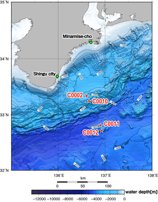
Figure 1: NanTroSEIZE study area and drilling Sites
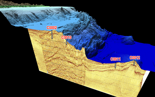
Figure 2: 3D Image of sea floor topography and subseafloor structure at NanTroSEIZE sites
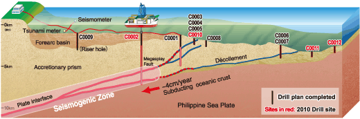
Figure 3: NanTroSEIZE Drilling Plan
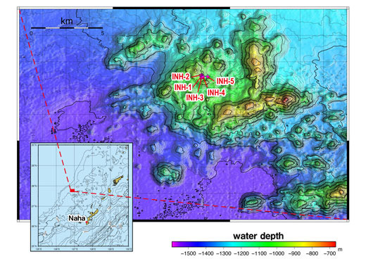
Figure 4. DEEP HOT BIOSPHERE study area and drill sites
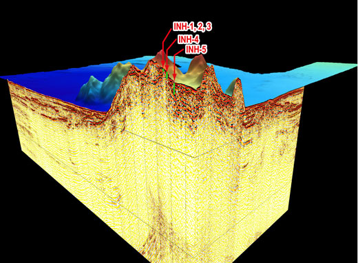
Figure 5: 3D Image of sea floor topography and subseafloor structure at Deep HOT BIOSPHERE sites
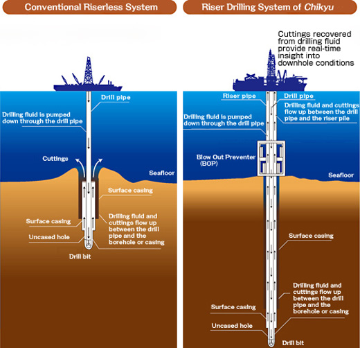
Figure 6: Riserless system (left) and Riser system (right)
Contacts:
-
Japan Agency for Marine-Earth Science and Technology
(For expeditions) - Yasuo Yamada, Manager
Planning and Coordination Department
Center for Deep Earth Exploration (CDEX)
- (For publication)
-
Toru Nakamura, e-mail: press@jamstec.go.jp
Manager, Planning Department Press Office