December 13, 2010
Japan Agency for Marine-Earth Science and Technology
Integrated Ocean Drilling Program (IODP)
CHIKYU Completes Expedition 332
NanTroSEIZE Stage 2: Riserless Observatory-2
The Deep-Sea Drilling Vessel Chikyu, operated by the Japan Agency for Marine-Earth Science and Technology (JAMSTEC), has successfully completed Integrated Ocean Drilling Program (IODP) (*1) Expedition 332: NanTroSEIZE Stage 2: Riserless Observatory-2(*2), on 11 December in the Kumano Basin, off the Kii Peninsula. The expedition successfully deployed a long-term borehole observatory, which was developed as part of the ocean and earth exploration system, a project pursued as one of Japan’s “Key Technologies of National Importance”. Especially in event of earthquakes, the realtime near-field geophysical observations and retrieval of data will provide invaluable insights into the mechanism of great earthquakes.
Primary operations:
Operations included replacing the previously installed temporary observatory for borehole temperature and pore pressure measurement at Site C0010 (water depth: 2,523.7m, casing depth: 544.3m), with an improved pore pressure and temperature monitoring observatory. The new system is equipped with a pore fluid sampler and a biosampler, as well as a chamber for in-situ microbial incubation.
The expedition also performed riserless drilling with LWD (*3) up to 980 m below seafloor close to the future ultra-deep riser drill Site C0002 (water depth: 1,937m). Following casing and cementing, a permanent long-term observatory was installed at the site (Fig. 1, 2, and 3).
Science participants include Co-Chief Scientists Dr. Eiichiro Araki (JAMSTEC) and Dr. Achim Kopf (University of Bremen), Expedition project Manager Sean Toczko, and six other scientists from Japan, the U.S. and Europe.
Primary scientific results:
- 1)
- Installation of the long-term observatory at Site C0002
The observatory, a “CORK” (Circulation Obviation Retrofit Kit), consists of a suite of sensors for downhole measurement including (1) a volumetric strainmeter, (2) a tiltmeter, (3) a thermometer array (4) pressure ports, (5) a broadband seismometer, (6) short-period seismograph, and (7) three-component geophones (Fig. 4).
Site C0002 is located at the subduction end of the Tokai Earthquake’s focal region, the area responsible for Magnitude-8 class earthquakes that historically occur at intervals of between every 100 and 150 years. The newly-installed observatory was cemented in the openhole below the casing, which will allow for monitoring microseismic changes within the fault zone and surrounding crust with much higher sensitivity and precision than those fixed onto a layer of soft sediment. - 2)
- Provisional borehole observation at Site C0010
The goal at Site C0010 is to drill into a large major splay fault (megasplay fault) responsible for major earthquakes in the Tonankai Region (southeastern coast of Japan), and to install an observatory system for long-term monitoring of the downhole conditions. IODP Expedition 319, conducted from May to August 2009, drilled a riserless hole into the megasplay fault and deployed a temporary monitoring package in the hole for pore fluid pressure and temperature measurement.
IODP Expedition 332 successfully recovered this observatory and collected robust and valuable pore pressure and temperature data from over a period of 15 months since the installation. The measurements recorded showed a tidal response of pore fluid pressure in the formation, as well as signs of past earthquake and tsunami occurrences in the Pacific Basin and crustal deformation associated with them. Such records are significantly important to better plan the installation of a long-term borehole observatory at this site.
In addition to pore fluid pressure and temperature measurement, the newly-deployed observatory is equipped with an osmosampler to detect changes in pore fluid chemistry, which is believed to be affected by seismogenic activities. The instrument package also includes a biosampler and an in-situ incubator. This monitoring system is to be used for geophysical and microbial observations until the hole is revisited for the installation of a permanent observatory in the future.
Future perspective
Scientists plan to deploy a permanent borehole observatory at Site C0010 to monitor geophysical changes in the megasplay fault. Connecting the observatory with the Dense Oceanfloor Network System for Earthquake and Tsunamis (DONET) being placed in the Kumano Basin will establish an integrated monitoring network covering the seafloor and subseafloor crust. This will enable real-time observation of seismic activities in the earthquake-prone Tonankai region.
Future schedule of Chikyu
The Chikyu is engaged in her next mission IODP Expedition 333: NanTroSEIZE Stage 2: Inputs Coring 2 and Heat Flow, from 12 December to 10 January 2011.
*1. The Integrated Ocean Drilling Program (IODP) is an international marine research drilling program dedicated to advancing scientific understanding of Earth by monitoring, and sampling subseafloor environments. Through multiple platforms, scientists explore IODP principal themes: the deep biosphere, environmental change, and solid Earth cycles. IODP has operated since October 2003, funded jointly by the Japan Ministry of Education, Culture, Sports, Science and Technology and the U.S. National Science Foundation. Additional support is provided by the 17-member European Consortium of Ocean Research Drilling, the People’s Republic of China, the Republic of Korea, Australia, India, and New Zealand.
*2 Nankai Trough Seismogenic Zone Experiment (NanTroSEIZE)
Project outline
The NanTroSEIZE drilling project consists of four stages in all, designed to conduct drilling operations at several sites located along a line orthogonally crossing the Nankai Trough region from Shikoku Basin (seaward) to Kumano Basin (Fig. 3).
Stage 1
Expeditions involved riserless drilling into the shallow portions (at a depth of 1400 mbsf and above) of the megasplay fault and plate boundary thrust. Data were collected to characterize subsurface geologic distribution, deformation structure and state of stress.
Stage 2
The goal of Stage 2 is to penetrate the upper portion of the seismogenic zone of great earthquakes and unravel its geological structure and state, using riser and riserless drilling. The drilled holes are to be used for the future installation of long-term observatories to monitor earthquake generation processes. Coring the subduction inputs before they are transported to the seismogenic zone is also planned to document their initial conditions including composition, architecture and geophysical properties.
Stage 3
Expeditions will focus on “ultra-deep” drilling that can reach the seismogenic zone, on which great earthquakes have repeatedly occurred. Operations include direct core sampling from the seismogenic zone to understand the seismogenic mechanism from a material science point of view.
Stage 4
In this Stage, long-term observatories will be deployed in the ultra-deep borehole. Ultimate future goals include connecting the NanTroSEIZE borehole sensors to an underwater seismic monitoring network, called Dense Ocean-floor Network for Earthquakes and Tsunamis (DONET), so that real-time data from earthquake occurring sites can be made available.
*3 LWD (Logging While Drilling)
LWD is a technique to measure geophysical properties at a site while drilling, through physical measurement sensors attached near the drill bit. With this technique, core sampling is not possible; however, continuous in-situ measurement of downhole conditions allows for characterizing the geology at the site in a relatively short time. In addition to valuable science data, the LWD can provide information to ensure the safety of the following coring operations and avoid risk. As such, LWD is a very effective tool to drill in complex geology, like the Nankai Trough.
*4. Dense Ocean-floor Network System for Earthquakes and Tsunamis (DONET)
DONET is a system being built on the ocean-floor in the Kumano Basin to establish a real-time observatory network for the possible Tonankai earthquake. The data collected will be used not only for better prepare for earthquake disasters but also for enhancing numerical models for earthquake prediction. Using sensors being placed at multiple locations on the deep seafloor, DONET will measure changes related to seismic activities simultaneously and in real time, which will be transferred to research institutes involved, including the Japan Meteorological Agency, the National Research Institute for Earth Science and disaster Prevention and academic institutes.
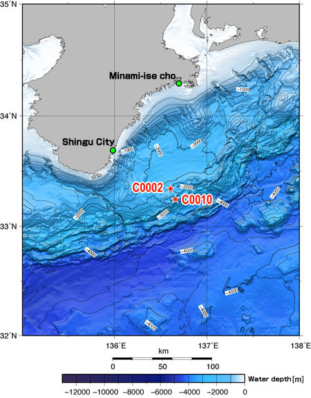
Figure 1: NanTroSEIZE study area and drilling Sites
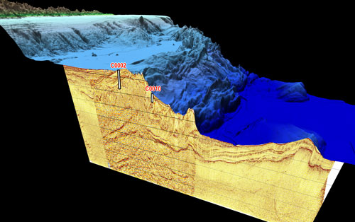
Figure 2: 3D Image of sea floor topography and subseafloor structure at NanTroSEIZE sites
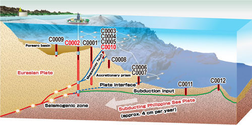
Figure 3: NanTroSEIZE Drilling Plan (Sites in red: Drill sites in Exp. 332)
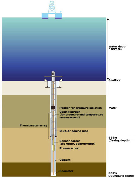
Circulation obviation retrofit kit (CORK) Schematic
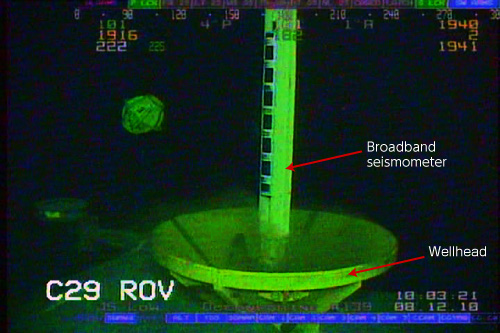
Photo: Lowering of CORK
(Photographed by a ROV, December 8, 2010)
JAMSTEC has launched a special website for Expedition 332.
http://www.jamstec.go.jp/chikyu/nantroseize2010/e/
The website features details of the expedition, profiles of scientists, and reports and updates from Chikyu.
Contacts:
- Japan Agency for Marine-Earth Science and Technology
(For the expedition) - Yasuo Yamada, Manager
Planning and Coordination Department
Center for Deep Earth Exploration (CDEX)
Atsushi Nakayama, Group Leader
Research Planning Group
Earthquake and Tsunami research project for Disaster Prevention
- (For IODP and DONET)
- Toshihiko Hoshino, Deputy Director, Planning Department
- (For publication)
-
Toru Nakamura, e-mail: press@jamstec.go.jp
Manager, Planning Department Press Office