January 13, 2011
Japan Agency for Marine-Earth Science and Technology
Deep-Sea Drilling Vessel CHIKYU Completes
IODP Expedition 333
NanTroSEIZE Stage 2:
- Subduction Inputs 2 and Heat Flow
The deep-sea drilling vessel CHIKYU, operated by the Japan Agency for Marine-Earth Science and Technology (JAMSTEC), successfully completed the IODP(*1) Expedition 333: NanTroSEIZE Stage 2 “Inputs Coring 2 and Heat Flow(*2) on 10 January, 2011. The expedition has been carried out in the Kumano Basin, off the coast of Kii Peninsula since 12 December, 2010.
Summary
The expedition involves drilling and coring of subduction inputs and heat flow measurements to better understand geophysical properties driving large subduction earthquakes at the margin of the Philippine Sea Plate which subducts beneath the Eurasian Plate. Subduction input consists of basaltic basement and sediment accumulated on it before an oceanic plate subducts underneath a continental plate.
Expedition 333 started off its operations with drilling and coring at Site C0018 (water depth: 3084.35 meters) to a depth of 3314.2 meters below seafloor (mbsf). These sediments are believed to be transported in response to submarine landslides.
In an attempt to explore the initial state of subduction inputs, scientist drilled and cored at Site C0011 (water depth: 4050.5 m) and Site C0012 (water depth: 3510.5 m) in Shikoku Basin, an outer region of the Nankai Trough (Fig. 1 and 2). These sites were drilled for cores during IODP Expedition 322 from September to October 2009. Expedition 333 sampled input sediments and underlying basaltic basement using riserless drilling, to a depth of 380 mbsf and 630.5 mbsf respectively. High-quality borehole temperature measurements were also conducted to estimate heat flow, a parameter significantly characterizing material properties.
The expedition was led by Co-chief Scientists, Toshiya Kanamatsu, Senior Research Scientist, JAMSTEC, and Pierre Henry, Senior Scientist, Centre National de la Recherche Scientifique (CNRS), France, and joined by 23 scientists from Japan, Europe, the U.S., China and South Korea.
Primary scientific operations
1. Drilling and coring the submarine landslide sediments at Site C0018
The expedition involved drilling a hole at Site C0018 to a depth of 314.2 mbsf in an attempt to understand the relationship between earthquake occurrence and submarine landslides.
The drilling penetrated six layers of submarine landslide deposits. At the lowest, a 62 meters thick submarine landslide deposit was confirmed at depths of 127-189 mbsf. This layer is overlain and underlain by volcanic ash layers which are widely found around Japan. The erupted age of the upper ash layer suggests that the landslide occurred about one million years ago. Cores collected in the submaine landslide layers at C0018 revealed various structures, which are indicative of sediment deformation associated with submarine landslides (Photo 1). The sedimentary sequence above this thick deposit comprises smaller landslide deposits and homogeneous clay; whereas a rhythmic turbidite sequence(*3)(Photo. 2) was recovered beneath the thick deposit. A drastic change in sedimentary environments between the submarine landslide and turbidite sequences may be a factor influencing the cause of the landslides.
2. Drilling and coring at C0011 and C0012
The aim of the drilling at both sites was to investigate into diagenetic changes in subduction inputs. Drilling was performed down to a depth of 380 mbsf at C0011 and 180 mbsf at C0012. Successful core recovery allows continues stratigraphic analyses of the cores. Shipboard analyses of the retrieved cores indicated that the alteration of sediment properties occurred in specific horizons. At C0012, researchers also obtained a high quality sections at sediment-basalt interface. The hole was deepened further up to a depth of 630.5 mbsf in order characterize the alteration of the basaltic basement.
Formation temperatures were measured with the advanced piston corer temperature tool (APCT-3) at selected depth horizons at both sites.
The results showed the higher heat flow at C0012 than that at C0011, providing valuable clues to understanding the fluid circulation at input sites.
Future perspective
With core samples obtained from Site C0018, scientists plan to study detail structural analysis and geotechnical experiment, submarine landslide dynamics, and its relationship with earthquakes and tsunamigenic potential.
For core samples obtained from the sites C0011 and C0012, analysis of sediment and crust composition, geomechanical experiments and hydrological modeling will be used to characterize incoming sediments and igneous basement prior to their arrival at the subduction front and seismogenic zone. The results will be combined with that from Expedition 322 implemented in 2009. These studies are expected to contribute to developing subduction earthquake models and mitigation for earthquake disasters.
Upcoming schedule of CHIKYU
- January 10th - 14th, 2011
- Unloading materials at Shingu Port
Cruise to Shimizu Port - January 15th - February 4th
- Loading materials at Shimizu Port and maintenance of drilling equipment
- February 5th - 27th
- Engaged in JOGMEC expedition
(JOGMEC: Japan Oil, Gas and Metals National Corporation) - February 27th - March 3rd
- Completion of JOGMEC expedition and unloading materials at Shimizu Port
Cruise to Hachinohe Port - March 7th - 14th
- Loading materials
- March 15th May 21st
- IODP Expedition 337: Deep Coalbed Biosphere off Shimokita
*The above schedule is subject to change because of the weather and operational requirements.
*1. The Integrated Ocean Drilling Program (IODP) is an international marine research drilling program dedicated to advancing scientific understanding of Earth by monitoring, and sampling subseafloor environments. Through multiple platforms, scientists explore IODP principal themes: the deep biosphere, environmental change, and solid Earth cycles. IODP has operated since October 2003, funded jointly by the Japan Ministry of Education, Culture, Sports, Science and Technology and the U.S. National Science Foundation. Additional support is provided by the 17-member European Consortium of Ocean Research Drilling, the People’s Republic of China, the Republic of Korea, Australia, India, and New Zealand.
*2 Nankai Trough Seismogenic Zone Experiment (NanTroSEIZE)
Project outline
The NanTroSEIZE drilling project consists of four stages in all, designed to conduct drilling operations at several sites located along a line orthogonally crossing the Nankai Trough region from Shikoku Basin (seaward) to Kumano Basin (Fig. 2).
Stage 1
Expeditions involved riserless drilling into the shallow portions (at a depth of 1400 mbsf and above) of the megasplay fault and plate boundary thrust. Data were collected to characterize subsurface geologic distribution, deformation structure and state of stress.
Stage 2
The goal of Stage 2 is to penetrate the upper portion of the seismogenic zone of great earthquakes and unravel its geological structure and state, using riser and riserless drilling. The drilled holes are to be used for the future installation of long-term observatories to monitor earthquake generation processes. Coring the subduction inputs before they are transported to the seismogenic zone is also planned to document their initial state including composition, architecture and geophysical properties.
Stage 3
Expeditions will focus on “ultra-deep” drilling that can reach the seismogenic zone, on which great earthquakes have repeatedly occurred. Operations include direct core sampling from the seismogenic zone to understand the seismogenic mechanism from a material science point of view.
Stage 4
In this Stage, long-term observatories will be deployed in the ultra-deep borehole. Ultimate future goals include connecting the NanTroSEIZE borehole sensors to an underwater seismic monitoring network, called Dense Ocean-floor Network for Earthquakes and Tsunamis (DONET), so that real-time data from earthquake occurring sites can be made available.
*3 Turbidite
Turbidites are sediments that are transported and deposited by turbidity currents, with sand and mud layers alternating each other.
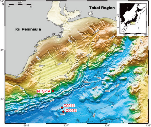
Figure 1: NanTroSEIZE study area and drilling Sites
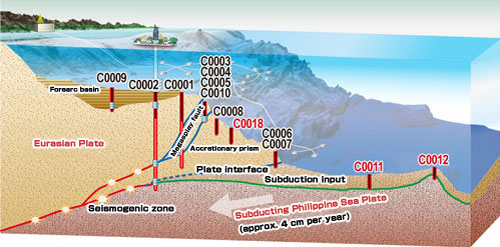
Figure 2: NanTroSEIZE Drilling Plan (Sites in red: Drill sites in Exp. 333)
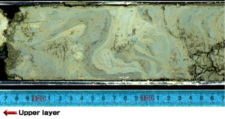
Photo 1: Convolute structure in submarine landslide deposits
(C0018: 139 msbf)
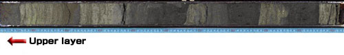
Photo 2: Turbidite sequence
(C0018: 201-202 msbf)
Contacts:
- Japan Agency for Marine-Earth Science and Technology
(For the expedition) - Yasuo Yamada, Manager
Planning and Coordination Department
Center for Deep Earth Exploration (CDEX)
- (For the expedition)
- Toshihiko Hoshino, Deputy Director, Planning Department
- (For publication)
-
Toru Nakamura, e-mail: press@jamstec.go.jp
Manager, Planning Department Press Office