February 4, 2011
Japan Agency for Marine Earth Science and Technology
Synthetic Aperture Sonar Produces High-resolution Acoustic Imagery of Hydrothermal Vents
~ Promising Results by Next-generation Deep-Sea Exploration Technology ~
Overview
Researchers from the Institute for Research on Earth Revolution (IFREE) and the Marine Technology Center (MARITEC) at the Japan Agency for Marine-Earth Science and Technology (JAMSTEC), have successfully obtained clear and detailed acoustic imagery (*2) of hydrothermal vents and surrounding biological communities, using synthetic aperture technique with accurate motion compensation (Fig. 1, *1). The sonar system is being developed under the project for "Next-generation Deep-Sea Exploration Technology", which has been pursued as one of the "Key Technologies of National Importance" in Japan. The study was the first to apply synthetic aperture techniques to the exploration of hydrothermal vents, which showed promising results for future mineral explorations in hydrothermal fields.
The study was conducted in the Wakamiko Caldera (Fig.2), in the Kagoshima bay of southern Japan, and led by Takashi Kasaya of the Subseafloor Dynamics Research Team at IFREE, and Takao Sawa of the Advanced Marine Technology Research Program at MARITEC.
Background
In the Aira Caldera, northern Kagoshima Bay (Fig. 2), volcanic activities of the Wakamiko Caldera at a depth of 200 meters and the active Sakurajima Volcano are very high. The hot fluids and gas, steaming from such submarine vents, have been observed in the Wakamiko Caldera. Their bubbles sometimes ascent to the sea surface and the phenomenon is locally called "Tagiri."
The magma sources of this volcanism are estimated to be supplied from the same magma chamber below the Aira Caldera. Detailed survey of the volcanic activity of the Wakamiko Caldera is therefore essential to estimate the energy budget of the volcanic system of the Aira Caldera.
In addition, hydrothermal systems closely relates to the formation of hydrothermal deposits, which are attracting the public attention as a promising energy or mineral resource. Understanding the extent of hydrothermal systems will therefore contribute to advancing research on the sub-seafloor material flow and mineral formation processes.
The Wakamiko Caldera, which is totally submerged, needs to be observed using underwater devices. Submersibles may lend themselves a powerful tool but the survey area at any given time is often limited. For mapping the hydrothermal fields, an accurate mapping technique over a wide area of topography had to be developed.
For effective mapping of the seafloor topography, to which light and electromagnetic waves can not reach, it is particularly essential to use acoustic technology to obtain high-resolution images over wide areas. The synthetic aperture sonar (SAS) technique, developed by JAMSTEC, has made this possible.
In this study, researchers mounted the beam-steering (*3) SAS system onto a small, lightweight neutral buoyancy platform (*4), and used it for investigating hydrothermal vents in the Wakamiko Caldera. This sonar system is being developed as one of the Key Technologies of National Importance.
Results
The survey was conducted in the Wakamiko Caldera in Kagoshima Bay from October 12th to the 15th, 2010. The synthetic aperture sonar (SAS) system(Fig.1) was mounted on a platform measuring 2.3m(W) and 1.2m(D). The neutral buoyancy platform was towed along by a 15-ton support boat at a depth of 3 meters below the water surface. The boat and the platform were spaced about 10 meters apart (Fig. 3). The acoustic signals reflected from the seafloor were recorded on the shipboard unit.
The SAS survey covered the habitat of Lamellibrachia Satsuma, a type of tubeworm, and hydrothermal vent areas previously confirmed by submersible dives or the "Tagiri" phenomena (Fig.4).
The survey around the tubeworm and hydrothermal areas revealed the detailed topography and filament-like sonar reflections related to the hydrothermal activity.
| i | The analysis of high-resolution SAS images obtained around the tubeworm habitat revealed filament-like reflections of sonar signals - an indication of hydrothermal activity in the east side of the 100-m sea mound. Near the mound's summit on the north side, as well as the southern end of the mound, the images depicted bare rocks and topographic undulations which are considered to correspond to the tubeworm habitats (Fig. 5). |
| ii | The imaging of the caldera floor portrayed a wider distribution of the hydrothermal vents than that previously identified by the submersible surveys. Furthermore, even in areas absent of the filament-like reflections, many topographic undulations apparently distinguishable from the surrounding muddy sediments were identified. These imply that hydrothermal active sites may change with time (Fig.6). |
These results could not have been obtained without the synthetic aperture sonar capable of high along-track resolution, which proved itself as a powerful tool in ocean explorations. The system can survey the area 12500 times larger than that of optical cameras per hour, and provides 80 times more pixels per hour than that of the conventional sonars(Table1).
Future perspectives
The study verified the distribution of hydrothermal vents along detailed topography in the Wakamiko Caldera. Combined with geochemical measurements by future submersible surveys over a wide area, the study on the hydrothermal mechanism in the Wakamiko caldera will further be promoted.
The SAS system developed by JAMTEC is compatible with small-seized boats. This makes it applicable for surveys in shallow or closed waters, and for environmental assessments prior to port improvement work. When modified for use in deep waters, the system will become a powerful tool for exploring deep-sea hydrothermal ore deposits. It can also be applicable for preliminary assessment of the proposed drill sites.
*1. Synthetic aperture sonar
In general, the performance of sonar systems is proportionate to the size of a sonar aperture (or antenna). Large apertures allow for sharp array beams and increase the resolution. The synthetic aperture sonar (SAS) technique uses a method which synthetically generates larger apertures. It involves multiple transmissions of signals from a moving sonar to the same target. The signals reflected by the target are combined and processed on a computer which synthesizes a large aperture. The synthetic aperture sonars are comparable in size and weight to conventional sonars, but sharp acoustic beams do not attenuate over long range distances, allowing for much higher resolution and noise mitigation.
*2. Acoustic imagery
Instead of radio waves that do not propagate in the sea water, acoustic waves are widely used in underwater surveys and communication. Acoustic imagery techniques involve acoustic waves being sent from a sonar source toward the ocean floor (transmission beams), and the return echoes reflected from the seafloor (reception beams), which are processed to produce underwater imagery.
*3. Beam steering
Beam steering is a technique to steer radio or acoustic beams in desired angular directions, by delaying the timing of the input and output of individual elements in the array or antenna. The technique allows for the reception of reflected echoes at a desired timing, generating sharp acoustic beams.
*4. Neutral buoyancy towed vehicle
Neutral buoyancy is the state in which the physical mass of an object equals the mass it displaces in the surrounding water. A neutral buoyancy towed vehicle is a platform which is towed along by a support ship at a constant depth (at which it becomes neutrally buoyant) and profiles ocean bottoms. It is like an "underwater kite".
Appendix
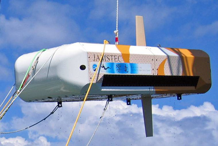
Figure 1: Neutral buoyancy towed vehicle
Width: 2.3 m, Depth: 1.2m, Air weight: 100kg
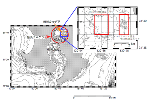
Figure 2: Southern Kyushu and enlarged view of the survey area
The Sakurajima Volcano and the Wakamiko Caldera are located in the Aira Caldera, in northern Kagoshima. The red framed areas indicate the tubeworm habitat (right) and the area of Tagiri (left).
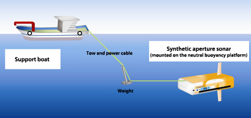
Figure 3: Schematic diagram of the survey
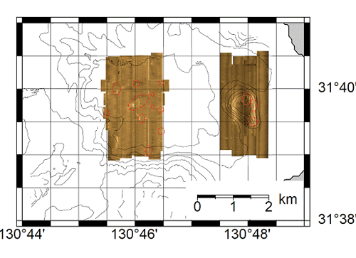
Figure 4. Acoustic images obtained from the study
The brown shaded areas on the right represent the mound where the habitation of the tubeworms has been confirmed. The left represents the caldera floor at which the Tagiri phenomena and hydrothermal vents were previously confirmed. Red circles denote areas of hydrothermal activity detected this time.
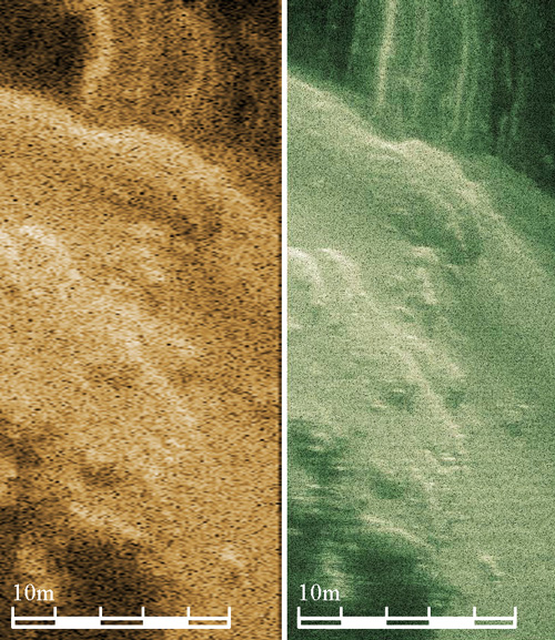
Figure 5. Comparison of sonar images (1):an image of the tubeworm habitat with aconventional sonar (left) and that with a high-resolution SAS.
The image on the right-hand not only depicts the detailed topography of the area but also the clear and sharp image of filament-like sonar reflections.
The distance to the target: 130 meters. The size of the synthetic aperture: 7 meters
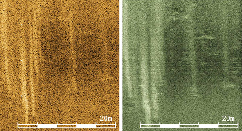
Figure 6. Comparison of sonar images (2):an image of the caldera floor with a conventional sonar (left) and that with a high-resolution SAS.
The SAS processing depicts multiple filament-like reflections and the detailed topography, which had never been detected with the conventional processing systems. Such small undulations are also detected around the area without a hydrothermal activity.
The distance to the target: 250 meters. The size of the synthetic aperture: 10 meters
Table 1: Comparison of performance
| Optical camera | Conventional side scan sonar | Beam-steering SAS | |
| Resolution*(m) | 0.002x0.002 | 6.5x0.05 | 0.09x0.09 |
| Survey area/h(m2/h) | 864 | 5.40million | 10.8 million |
| Pixels/hr(pixel/h) | 216 million | 1.66 million | 1.33 billion |
*Values at maximum rage/2
Contacts:
- Japan Agency for Marine-Earth Science and Technology
(For the survey) - Takashi Kasaya, Research Scientist
Subseafloor Dynamics Research Team
Institute for Research on Earth Evolution (IFREE) - (For the synthetic aperture sonar)
- Takao Sawa, research Scientist
Advanced Marine Technology Research Program
Marine Technology and Engineering Center (MARITEC) - (For Key Technologies of National Importance)
- Toshihiko Hoshino, Deputy Director, Planning Department
- (For publication)
- Toru Nakamura, e-mail: press@jamstec.go.jp
Manager, Planning Department Press Office