December 2, 2011
JAMSTEC
Seafloor Displacement Caused by the 2011 Tohoku-Oki Earthquake
- Fault Rupture Reaching the Trench Axis -
Overview
Following the March 2011 Tohoku-Oki earthquake, JAMSTEC researchers carried out a multibeam bathymetric survey across the rupture zone from 22 to 23 March, to examine the seafloor displacement associated with the large earthquake. Data were obtained along the survey transect (Fig.1), which had been used for bathymetric surveys in 1999 and 2004.
A comparison of bathymetry before and after the earthquake suggests a significant displacement of seafloor, approximately 50 meters horizontally towards the east-southeast and 7-10 meters upwards. There was no major change in seafloor elevation between 1999 and 2004.
This study was reported in the December 2 issue of the journal Science, authored by Toshiya Fujiwara and his colleagues at the Institute for Research on Earth Evolution(IFREE) as well as at the Earthquake and Tsunami Research Project for Disaster Prevention.
- Title:
- The 2011 Tohoku-Oki Earthquake: Displacement Reaching the Trench Axis
- Authors:
- Toshiya Fujiwara1, Shuichi Kodaira1, Tetsuo No1, Yuka Kaiho1, Narumi Takahashi2, Yoshiyuki Kaneda2
- 1.
- Institute for Research on Earth Evolution, JAMSTEC
- 2.
- Earthquake and Tsunami Research Project for Disaster Prevention, JAMSTEC
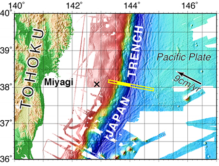
Figure 1.
A: Survey area with bathymetric data. The yellow line represents the survey track. The cross ("x") indicates the epicenter of the primary rupture in the 2011 Tohoku-Oki earthquake.
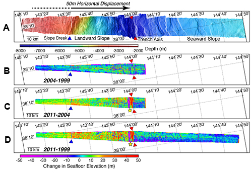
Figure 2.
A. Bathymetry obtained along the track in 2011
Red triangles mark the trench axis. The blue triangle marks the landward slope break*. From the slope break, the seafloor becomes steeper towards the trench axis.
*Slope break: A sudden change in slope gradient
B. Change in seafloor elevation between 2004 and 1999
No clear change in seafloor elevation was confirmed. Changes colored in green and yellow are considered measurement errors.
*Bathymetric errors average at about 0.5 % of water depth.
C. Change in seafloor elevation between 2011 and 2004
Uplift of the seafloor was observed throughout the landward side (indicated by the dotted and solid black line). In the area under the solid black line (from the slope break to the trench axis), the upward and horizontal displacement was evident due to rugged topography. Researchers had estimated similar values of displacement in their preliminary report in April (Fig. D). The yellow star marks the location of probable submarine landslide.
D. Change in seafloor elevation between 2011 and 1999
After in-depth analyses, the coseismic displacement was estimated to be 56 meters along the east-southeast horizontally and 10 meters vertically.
The results shown in Figure B, C and D suggest that the seafloor displacement occurred after 2004, and the extent of it from the source area to the trench axis was estimated to be about 50 meters east-southeast and 7 to 10 meters upward.
Contacts:
- Japan Agency for Marine-Earth Science and Technology
(For the study) - Toshiya Fujiwara
Research Scientist, Subseafloor Dynamics Research Team,
Plate Dynamics Research Program, Institute for Research on Earth Evolution - (For publication)
- Hikaru Okutsu, e-mail: press@jamstec.go.jp
Senior Administrative Specialist, Planning Department Press Office