Press Releases
JAMSTEC
Kagoshima University
Disaster Prevention Research Institute,
Kyoto University
The 2016 Mie-ken Nanto-oki Earthquake
Occurred Along a Plate Boundary Last Active in 1944
- New findings from an integrated seafloor and sub-seafloor monitoring network -
1. Overview
An international research team formed by Dr. Laura M. Wallace at the University of Texas and Dr. Eiichiro Araki & Dr. Ayako Nakanishi at the Japan Agency for Marine-Earth Science and Technology (JAMSTEC; Asahiko Taira, President) has evaluated an Mw 6.0 earthquake that struck ~50 km offshore from the Kii Peninsula of southwest Honshu, Japan on April 1, 2016. The earthquake occurred directly beneath their cabled offshore monitoring network, the Dense Oceanfloor Network System for Earthquakes and Tsunamis (DONET)i along the Nankai Trough subduction zone, and within 25-35 km of two Long Term Borehole Monitoring System (LTBMS)ii observatories installed as part of an International Ocean Discovery Program (IODP)iii drilling project. The real-time data obtained from these integrated seafloor and sub-seafloor monitoring networks revealed that the earthquake and its aftershocks were located within the coseismic slip region of the 1944 Tonankai earthquake, on the plate boundary along the Nankai Trough. This result indicates that deformation processes have been in progress in this region since the 1944 earthquake and marks the first time that a complex process of earthquake occurrence and seafloor movements, as well as tsunamis, has been directly observed along the Nankai Trough plate boundary.
In order to better understand seafloor movements and seismic activity in the area, the scientists will further develop real-time seafloor observation systems including DONET and LTBMS and will also investigate plate boundary structures using drilling and other geophysical methods. These efforts will help advance research on the mechanisms and prediction of earthquakes in the Nankai Trough.
The above work was carried out in collaboration with researchers from the University of Texas, Pennsylvania State University, GNS Science, the University of Bremen, Kagoshima University, and Kyoto University. The results were published in the Journal of Geophysical Research on November 18, 2016 (JST).
Title: Near-field observations of an offshore Mw 6.0 earthquake from an integrated seafloor and sub-seafloor monitoring network at the Nankai Trough, southwest Japan
Authors: L.M. Wallace1, E. Araki2, D. Saffer3, X. Wang4, A. Roesner5, A. Kopf5, A. Nakanishi2, W.4 Power4, R. Kobayashi6, C. Kinoshita7, S. Toczko2, IODP Expedition 365 Science party
1Institute for Geophysics, University of Texas, Austin, Texas, USA
2JAMSTEC
3Department of Geology, Pennsylvania State University, USA
4GNS Science, Lower Hutt, New Zealand
5MARUM, University of Bremen, Germany
6Kagoshima University
7Disaster Prevention Research Institute, Kyoto University
iDONET: The Dense Oceanfloor Network System for Earthquakes and Tsunamis is a cabled submarine real-time seafloor observatory network for the monitoring of earthquakes and tsunamis, deployed around the Nankai Trough by JAMSTEC. The first phase of DONET, “DONET1”, started its operation in 2011. A total of 22 stations have been installed at water depths of 1,900-4,400 m in the Kumano forearc basin off the Kii Peninsula. The “DONET2” phase, with an additional 22 stations, was later added at water depths of 1,100-3,600 m from Kii-suido to east of Shikoku. These stations, equipped with strong-motion seismometers, broadband seismometers, quartz pressure gauges, differential pressure gauges, hydrophones, and precision thermometers, can observe broadband signals including crustal deformations, tsunamis, and other strong motions.
Since the completion of DONET2 at the end of March 2016, the DONET system has been operated by the National Research Institute for Earth Science and Disaster Prevention since April 1, 2016. The resulting real-time data are utilized by the Japan Meteorological Agency for earthquake early warnings and tsunami alerts.
iiLTBMS: The Long Term Borehole Monitoring System was developed to obtain real-time seismic data for the observation of seismogenic faults in IODP drilling holes. It aims to elucidate the initiation process of large earthquakes. Installed sensors include thermometers, broadband seismometers, tiltmeters, strainmeters, and pressure ports. The first LTBMS has been collecting real-time data at the IODP C0002 site since it was connected to DONET by the research vessel Kaiyo in January 2013 (as reported on February 5, 2013). In April 2016, the second LTBMS was installed by the D/V Chikyu within a borehole at 651 m below the seafloor at the IODP C0010 site during IODP scientific expedition 365 (as reported on April 28, 2016: http://www.jamstec.go.jp/cdex/j/developtec/holeobserb/ltbms/)
iiiIODP: The International Ocean Discovery Program is a multinational cooperative project started in October 2013, following the Integrated Ocean Drilling Program (IODP) carried out from October 2003 to 2013. The scientific drilling vessels D/V Chikyu (operated by Japan) and JOIDES Resolution (operated by the U.S) are utilized for expeditions, along with the option to charter mission-specific platforms from Europe. The program aims to shed light on global environmental changes, the earth’s mantle, crust dynamics, & tectonics, and the biosphere beneath the seafloor.
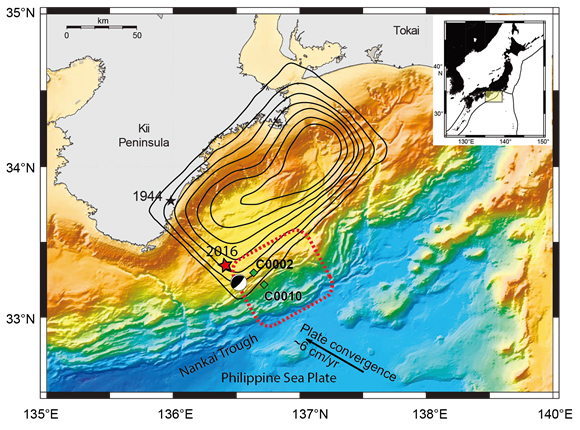
Figure 1. Tectonic setting of the Kii Peninsula region and the Nankai Trough; inset shows the geographic setting and location of main figure. Black contours (0.5 m intervals) show the rupture area of the 1944 Tonankai earthquake (Kikuchi et al., 2003; black star marks the epicenter). Red star marks the location of the 2016 Mie-ken Nanto-oki Mw 6.0 earthquake as determined by this study. Black and white circle shows the Global CMT location and focal mechanism solution for the earthquake (Dziewonski et al., 1981; Ekström et al., 2012); note that the GCMT location is seaward of our determined location. Dotted red lines show the region of Very Low Frequency Earthquakes identified by Ito and Obara (2006). Green diamonds are IODP borehole observatories.
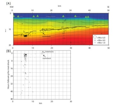
Figure 2. Cross-section of earthquake locations and aftershocks (A) and projected onto the Vp seismic model (see supplementary material), and time history of the earthquakes in the cross section with respect to the origin time of the main shock (B). P-wave velocity contours are labelled in km/s. The plate interface (black lines) is determined from interpretation of multi-channel seismic data and is in part derived from Park et al. (2002). Depth (y-axis) on top panel is in km below sea level. Green triangles show nearby DONET sites projected onto the cross-section.
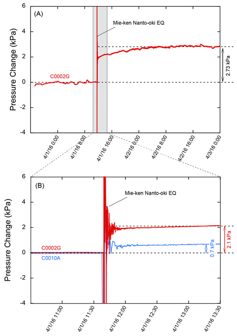
Figure 3. Borehole pressure changes during the 1 April, 2016 earthquake. (A) Pressure data at the IODP C0002 site from the ~2 day period surrounding the earthquake. (B) Closer view of the earthquake (gray box in A) showing pressure records from IODP sites C0002 (red) and C0010 (blue). Note that the temporary sensor at C0010 was retrieved several hours after the earthquake (on IODP Expedition 365), so is not shown in the top panel.
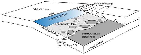
Figure 4. Schematic of possible heterogeneity of plate interface properties and slip behaviours beneath the outer forearc of the offshore Nankai Trough (modified from Bilek and Lay, 2002). This suggests that earthquakes similar to the 1 April 2016 Mw 6.0 earthquake may rupture moderate-sized unstable patches within the updip transition from the large seismogenic patch (that likely ruptures in great earthquakes) to a conditionally stable region characterized by Very Low Frequency Earthquakes (VLFEs; Ito and Obara, 2005; Obana and Kodaira, 2009; Sugioka et al., 2012) and possible slow slip.
Contacts:
- (For this study)
- Eiichiro Araki, Senior Research Scientist, Research and Development Center for Earthquake and Tsunami
- (For press release)
- Tsuyoshi Noguchi, Manager, Press Division, Public Relations Department