Press Releases
JAMSTEC
D/V Chikyu Completes International Ocean Discovery Program Expedition 380
- NanTroSEIZE Stage 3: Frontal Thrust Long-Term Borehole Monitoring System -
The Deep-sea Scientific Drilling Vessel Chikyu of the Japan Agency for Marine-Earth Science and Technology (JAMSTEC; President: Asahiko, Taira) completed all planned work for the International Ocean Discovery Program (IODP*1) Expedition 380, which began on January 12th of this year (reported Jan. 11, 2018).
1. Program Overview
This expedition has successfully achieved the objective of drilling down to 495m below the seafloor and installing a long-term borehole monitoring system (LTBMS, Figure 3) at site C0006 (Figures 1 and 2: 3,871.5 m below sea level) located at the toe of the Nankai Trough plate boundary fault. Chikyu entered the Shimizu port (Okitsu Wharf) in the Shizuoka Prefecture on February 7th, 2018.
2. Overview of Results and Outlook
Following sites C0002 and C0010 in the Nankai Trough, the expedition team installed a LTBMS at a third site, C0006. LTBMS is a system in which several sensors―(1) thermometer, (2) strainmeter, (3) seismometer, (4) tiltmeter, (5) geophones, (6) accelerometer and (7) pressure port― are installed, and it is fixed inside a drilled hole. The system is fixed to a stable stratum inside the borehole with cement and can observe and monitor minute fluctuations in the plate boundary fault and the surrounding Earth's crust over a long period of time with a high sensitivity and accuracy. Detailed crustal movements at the toe of the plate boundary fault (near the trench), which are related to the generation of tsunamis, are captured and the observation of the state of strain energy accumulation and seismic activities is possible through the measurement of changes and trends in the pressure and temperature of crustal fluids.
The LTBMS system installed at site C0006 is scheduled to connect with the Dense Ocean- floor Network System for Earthquakes and Tsunamis (DONET*2), which has been installed in the Nankai Trough; this system will enable real-time acquisition of borehole observation data as with the other LTBMS system.
*1 The International Ocean Discovery Program (IODP) is a multinational cooperative project that was started in October 2013. The scientific drilling vessel (D/V), Chikyu, operated by Japan, and the JOIDES Resolution, operated by the U.S., are utilized for expeditions. There is also an option for European countries to charter mission-specific platforms. The IODP’s mission is to shed light on global environmental changes, the mantle and crust dynamics and tectonics of the Earth, and the biosphere beneath the seafloor. IODP took over the Integrated Ocean Drilling Program conducted from October 2003 to 2013.
*2 Dense Ocean-floor Network System for Earthquakes and Tsunamis (DONET)
DONET is a monitoring system for earthquakes and tsunamis, developed by JAMSTEC, and installed on the seafloor in the Nankai Trough area to regularly observe and monitor earthquakes and tsunamis that occur in the sea. The system consists of DONET1 and DONET2. DONET1, installed on the seafloor 1,900–4,400 m below sea level in the Kumano Basin off the coast of the Kii Peninsula consists of 22 observation sites, which began operation in 2011. DONET2 consists of 29 observation points installed 1,100–3,600 m below sea level between Kii Channel and the basin off the coast of Shikoku, and installation was completed at the end of March 2016.
With the completion of DONET2, the DONET system was transferred to the National Research Institute for Earth Science and Disaster Resilience in April 2016. Data obtained by DONET are transmitted to institutions such as the Japan Meteorological Agency, in real-time, and are used for earthquake early warning and tsunami alerts.
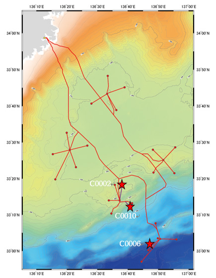
Figure 1. Location of the DONET1 and the LTBMS
Site C0006, where the drilling was performed, and LTBMS was installed during this expedition, approximately 100 km southeast of Shingu, Wakayama (33°2'N, 136°48'E)
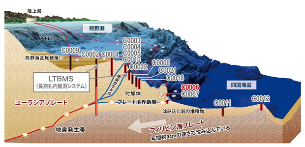
Figure 2. The site drilled in NanTroSEIZE (multiple boreholes have been drilled on the same site in some cases)
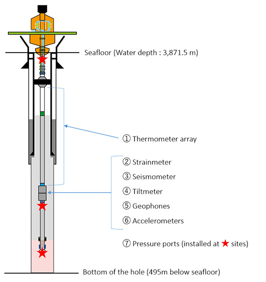
Figure 3. LTBMS and sensor configuration
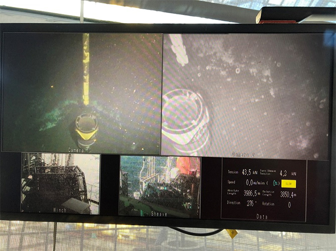
Photo 1: Re-entry process of drill pipes (taken by underwater camera)
The team drilled down to 399m beneath the ocean floor to set casing pipes for protection of the borehole. This photo, which was taken on January 26th, 2018, shows the re-entry process of drill pipes to the borehole. At water depths of 3,871.5m, the pipe’s inside diameter is about 50 cm, so the work was carefully carried out with checking underwater camera’s images.
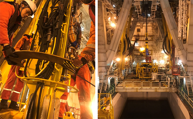
Photo 2 & 3 Preparation for installing wellhead assembly (CORK head)
LTBMS sensors are inserted into a drilled hole. After fixing them with cements, the wellhead assembly is installed on the top of the borehole. By connecting submarine cables with the well head assembly, then real-time monitoring of observational data will become available later.
Contacts:
- (For IODP and this expedition)
- Takehiko Yano, Director, Planning and Coordination Office, Center for Deep Earth Exploration
- (For press release)
- Tsuyoshi Noguchi, Manager, Press Division, Public Relations Department