Press Releases
JAMSTEC
The University of Tokyo
An attempt to derive precipitation increases in extratropical cyclones due to global warming based on high-accuracy satellite observations: Suggestions from high-resolution climate simulations
1. Main points of the press release
- ♦
- Precipitation from extratropical cyclones mainly contributes to the mid-latitude precipitation but prior climate simulations have not sufficiently simulated phenomena that are crucial for precipitation prediction (e.g., fronts, convection).
- ♦
- High-resolution climate simulation data analysis showed that the precipitation amount from oceanic extratropical cyclones can be scaled with only surface air temperature across present-day/future climates and across northern/southern hemispheres.
- ♦
- Our results suggest that precipitation change due to global warming in future can be estimated by conducting global high-accuracy satellite precipitation observations.
2.Overview
A joint international research team that includes researcher Chihiro Kodama and technical researcher Tatsuya Seiki from the Cloud-Resolving Model Development and Application Group, Research Center for Environmental Modeling and Application, Research Institute for Global Change, at the Japan Agency for Marine-Earth Science and Technology (JAMSTEC; president: Tadashi Matsunaga), and Professor Masaki Satoh from the Atmosphere and Ocean Research Institute (director: Tomohiko Kawamura) at the University of Tokyo, analyzed oceanic extratropical cyclones in present-day and future (about 100-yr ahead) climate simulation based on the nonhydrostatic icosahedral atmospheric model (NICAM *1) and Global Precipitation Mission (GPM) satellite observational data (Figure 1). Results showed that the precipitation amount from oceanic extratropical cyclones (*2) can mostly be scaled with surface air temperature in both present-day/future climates and northern/southern hemispheres (Figure 2). While the extent of increase in precipitation from extratropical cyclones is uncertain among researches, if the scaling made by our current research are correct, future changes in the precipitation from extratropical cyclones due to global warming can be estimated by accurate global observation of precipitation in the northern and southern hemispheres, where temperature of the extratropical cyclone is different among the two hemispheres.
Our results are not only expected to contribute to the 6th Assessment Report (AR6) of the Intergovernmental Panel on Climate Change (IPCC) (*3), but also highlight the importance of high-accuracy rainfall observations on a global scale.
This research was conducted with funding from the Integrated Research Program for Advancing Climate Models (TOUGOU), the FLAGSHIP2020 (Supercomputer Fugaku *4) Project within the priority study4 (Advancement of meteorological and global environmental predictions utilizing observational “Big Data”) (Issue number: hp160230, hp170234, hp180182) and grant-in-aid for scientific research JP17H04856 by Ministry of Education, Culture, Sports Science and Technology (MEXT). Additionally, Chihiro Kodama was supported by the Taro Matsuno Scholarship (established by JAMSTEC Fellow Taro Matsuno) to visit the Max Planck Institute for Meteorology for this study.
These results are published online in Geophysical Research Letters on November 14th, 2019 (JST).
Title: A new perspective for future precipitation change from intense extratropical cyclones
Authors: Chihiro Kodama 1,Bjorn Stevens 2,Thorsten Mauritsen 3,Tatsuya Seiki 1,Masaki Satoh 4,1
1. Research Institute for Global Change, JAMSTEC,2. Max Planck Institute for Meteorology,3. Department of Meteorology, Stockholm University,4. Atmosphere and Ocean Research Institute, The University of Tokyo
*1 NICAM: An atmospheric general circulation model that allows for advanced simulations with reduced uncertainty by explicitly calculating cloud formation/dissipation across the globe. Horizontal resolutions higher than in standard models are made possible by supercomputers, and 14-km mesh is usually used for multi-decadal climate simulations. Simulations with a mesh size of 870 m were conducted in a previous NICAM study.
*2 Oceanic extratropical cyclone: An extratropical cyclone is an atmospheric depression that forms in the mid/high latitudes (approximately 30° latitude north/south and beyond). North-south temperature differences are a source of energy, and these cyclones often move along with fronts. An oceanic extratropical cyclone here is defined as an extratropical cyclone that spent over half of its lifecycle over the ocean.
*3 6th Assessment Report (AR6) of the Intergovernmental Panel on Climate Change (IPCC): A report that includes the latest scientific findings on human-induced climate change, influences, responses, and mitigation strategies in order to provide a scientific foundation for climate change policies. A new report is drafted every 5–7 years, and AR6 is expected to be announced between 2021 and 2022.
Reference: http://www.env.go.jp/earth/ondanka/ipccinfo/index.html,
http://www.data.jma.go.jp/cpdinfo/ipcc/
*4 Supercomputer Fugaku: A supercomputer that will succeed the K Supercomputer with an expected 100-times increase in application performance capabilities. It is under development primarily by RIKEN and will begin operation around 2021.
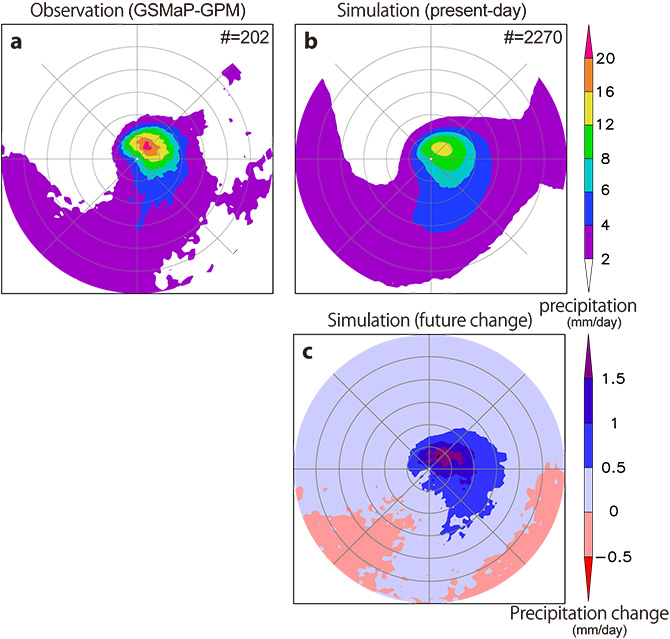
Figure 1. Mean rainfall distribution in the vicinity of an intense extratropical cyclone from a) observational data (GSMaP-GPM) extracted between April 2014 and March 2016; b) data for the years 1979–2003 extracted from a present-day climate simulation. Gray circles are drawn every 500 km, with the center of the extratropical cyclone placed in the middle of the map. c) Mean differences in precipitation between future simulated climate (2075–2099) and present-day climate (1979–2003).
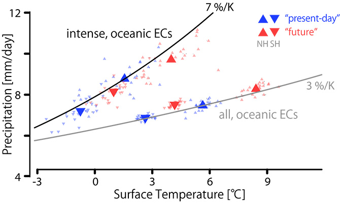
Figure 2. Relationship between surface air temperature, averaged from a radial distance approximately 550 km away from the center of an intense oceanic extratropical cyclone (above; black line) and all the oceanic extratropical cyclone (bottom; gray line), and precipitation amount. Blue indicates present-day climate, and red indicates future climate. ▲ indicates all the oceanic extratropical cyclones in the northern hemisphere, and ▼ indicates those in the southern hemisphere. The large triangles indicate 25-year averages, and the little triangles indicate 1-year averages.
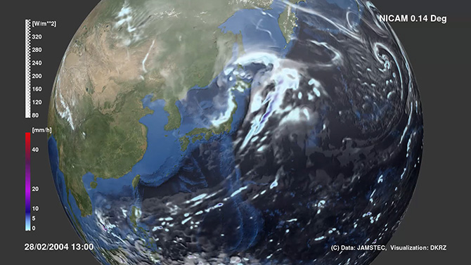
Reference map: Visualized simulation image. An extratropical cyclone forming over the sea northeast of Japan.
Contacts:
- (For this study)
- Takuma Miyakawa, Environmental Geochemical Cycle Research Group, Research Institute for Global Change, Earth Surface System Research Center
- (For press release)
- Public Relations Section, Marine Science and Technology Strategy Department