Press Releases
JAMSTEC
PUBLIC WORKS RESEARCH INSTITUTE
First-time success in remotely observing marine water vapors using an autonomous surface vehicle
1. Key points
- ◆
- Researchers have succeeded for the first time in remotely observing marine water vapors for approximately two months over the western tropical Pacific Ocean using autonomous surface vehicles.
- ◆
- The new, high-mobility and frequency method of observation may enable the detection of fluctuations in water vapor, which are a factor in the spawning of typhoons and the Baiu Front.
- ◆
- A greater understanding of the convection systems that occur and develop at sea is expected to improve the accuracy of precipitation forecasts.
2. Overview
Dr. Mikiko Fujita and colleagues of the Research Institute for Global Change, Japan Agency of Marine–Earth Science and Technology (JAMSTEC), in collaboration with the Public Works Research Institute, installed a Global Navigation Satellite System (GNSS) receiver (*1) on an autonomous surface vehicle (i.e., Wave Glider; Figs. 1 and 2). Using this set-up, researchers were able to successfully make remote observations of marine water vapors for the first time. The study period lasted for two months over the western tropical Pacific Ocean.
Accurately measuring water vapor is important for understanding the formation of clouds and precipitation. Atmospheric water vapor generally increases at a specific rate of change with increased atmospheric temperatures. Consequently, increases in sea surface temperatures due to climate change are assumed to strengthen both typhoons, which form at sea, as well as terrestrial convection systems (e.g., linear precipitation zones accompanying the Baiu Front) caused by the influx of massive amounts of water vapor from the sea. Terrestrial water vapor observation networks are being developed in order to capture such rapid changes in the amount of water vapor; however, satellite observations with low-frequency microwave radiometers are the primary method of quantitatively observing marine water vapors. The observation frequencies of these satellites are limited to less than once per day due to the constraints of their trajectories, rendering them insufficient for observing convection and precipitation patterns that form within several hours. Therefore, a dual-frequency GNSS receiver that was capable of estimating water vapor was installed on a Wave Glider, and trial observations for estimating precipitable water (*2) from GNSS satellite radio wave delays due to atmospheric water vapor were made by JAMSTEC and affiliated researchers for approximately two months over the western Pacific Ocean. The comparison of GNSS-derived precipitable water from the remote observations with those derived from conventional satellite observations equipped with a microwave radiometer and radiosonde observations showed that the Wave Glider system was capable of making observations at a similar level of accuracy (Fig. 3). In the future, it will be possible to use mobile autonomous vehicles to observe precipitable water with the same accuracy and frequency as that recorded on ships.
The primary aim of the study reported here was to confirm the operability and accuracy of the Wave Glider system by means of trial observations. Observing marine water vapors using highly mobile devices enables the detection of temporal changes in water vapor, which are the source of typhoons and convection systems, such as the Baiu Front; until now, this has proven difficult due to technological constraints. Further advances in the understanding of convection systems that occur and develop at sea are expected to contribute to the increased accuracy of precipitation forecasts, thereby improving risk assessments and mitigation.
This study was funded by the Japan Society for the Promotion of Science (JSPS) Grant-in-Aid for Challenging Research (Exploratory) [Principal investigator: Mikiko Fujita; Proposal no. 17K18963]. The results of this study were published by the Meteorological Society of Japan in the Scientific Online Letters on the Atmosphere on October 13 (JST).
- Title:
- Experimental observations of precipitable water vapor over the open ocean collected by autonomous surface vehicles for real-time monitoring applications
- Authors:
- Mikiko Fujita1, Tatsuya Fukuda2, Iwao Ueki1, Qoosaku Moteki1, Tomoki Ushiyama3, Kunio Yoneyama1
- Affiliations:
- 1. Research Institute for Global Change, JAMSTEC
2. Institute for Marine-Earth Exploration and Engineering, JAMSTEC
3. Public Works Research Institute
[Supplemental information]
- *1
- GNSS: Global Navigation Satellite System is the general term for positioning satellites, such as the Global Positioning System (GPS).
- *2
- Precipitable water: The vertically integrated amount of atmospheric water vapor from the ground surface to the upper atmosphere, which is expressed in millimeters, similar to precipitation.
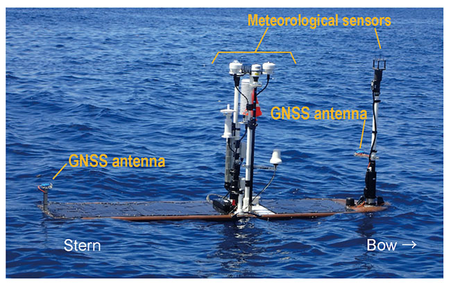
Fig. 1 Wave Glider (floating section) with a GNSS antenna and meteorological observation device installed in front and rear of the floating section, respectively.
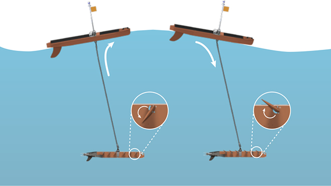
Fig. 2 Principles of Wave Glider propagation (from Liquid Robotics, Inc., link). The section of the glider in the ocean, which is connected to a float via an umbilical cable, moves up and down as the float passes over waves. The wings of the glider then change direction and propel in the forward direction.
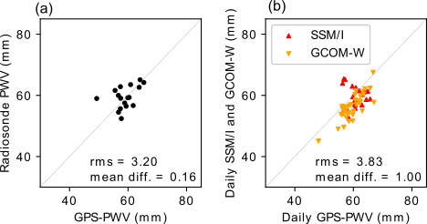
Fig. 3 Scatter plots of the precipitable water observed by the Wave Glider (x-axis, mm), compared with that observed by (a) radiosonde and (b) SSM/I and GCOM-W1. Abbreviations: GCOM, Global Change Observation Mission; PWV, pulse wave velocity; RMS, root mean square; SSM/I, Special Sensor Microwave Imager.
Contacts:
- (For this study)
- Mikiko Fujita, Researcher, Research Institute for Global Change, Dynamic Coupling of Ocean-Atmosphere-Land Research Program, JAMSTEC
- (For press release)
- Public Relations Section, Marine Science and Technology Strategy Department, JAMSTEC