[Column] A co-occurrence of a La Nina Modoki and a negative Indian Ocean Dipole Mode may bring an abnormal season
The latest observation confirms the weakening of a “super” El Niño that occurred last spring. In addition, a positive Indian Ocean Dipole Mode event also occurred last summer, but it has dissipated. Despite this, the western Indian Ocean is still experiencing higher-than-normal temperatures. According to the latest forecast from the Application Laboratory, a combination of a La Niña Modoki and a negative Indian Ocean Dipole Mode is likely to occur this boreal summer. Both the La Niña Modoki and the negative Indian Ocean Dipole Mode can cause abnormal weather around the world, including Japan. In particular, Indonesia and Australia (or East Africa) may experience an extremely wetter (or dryer)-than-normal condition. The combination of the two events also occurred in 2022. In the summer of 2022, most of Japan experienced higher temperatures, while northern Japan experienced excessive rainfall. The 2024 tropical climate condition might be similar to the 2020 condition in the sense that both a La Niña and a negative Indian Ocean Dipole Mode occurred after an El Niño and a positive Indian Ocean Dipole Mode in the previous year. In the summer of 2020, the Meiyu-Baiu rainfall was significantly enhanced, causing devastating flooding in Japan and central China. We should keep a close eye on future developments in the tropical oceans and their contribution to the Meiyu-Baiu rainfall activity.
What is a La Niña Modoki?
In a La Niña Modoki event, sea surface temperatures (SSTs) in the central area of the tropical Pacific Ocean cools and SSTs in both the eastern and western sides of the basin warm. Different from a La Niña phenomenon, in which SSTs in the eastern side of the tropical Pacific Ocean are cooler than normal, this phenomenon is known to influence variations in climate and sea level worldwide. For example, La Niña events tend to cause hotter summers in northern Japan, whereas La Niña Modoki events tend to enhance rainfall in western Japan. Modoki phenomena were discovered by Prof. Toshio Yamagata (former director of Application Laboratory) and their colleague when investigating the causes of the extremely hot summer heat experienced in Japan in 2004, when a cooler summer was expected due to an El Niño event (El Niño Modoki Website).
What is an Indian Ocean Dipole Mode?
This phenomenon is like an El Niño/La Niña, but seen in the tropical Indian Ocean. It occurs once every few years, from boreal summer to autumn. The Dipole Mode can have a positive or negative phase. When a negative event occurs, SSTs are higher than normal in the southeastern tropical Indian Ocean and lower than normal in the western part. It can cause heavy rainfall and flood damage in Indonesia, while droughts are more likely to occur in East Africa. In 2020, 2021, and 2022, negative Indian Ocean Dipole Mode events occurred, and many parts of East Africa experienced severe droughts that threatened food and drinking water security. (For more information, see the press release “On the predictability of the extreme drought in East Africa during the short rains season ~Key roles of the negative Indian Ocean Dipole~”, Nature Research Highlight).
The impact of Indian Ocean Dipole Mode events on weather and climate in mid-latitude countries (including Japan) and their relationships with El Niño/La Niña and El Niño Modoki/La Niña Modoki are still being actively studied.
Are an El Niño/La Niña Modoki and an Indian Ocean Dipole Mode predictable?
The dynamical seasonal prediction system called SINTEX-F by the Application Laboratory is skillful at predicting the occurrence of El Niño/La Niña Modoki events with high accuracy for more than one year using the supercomputer "Earth Simulator" (see the SINTEX-F website for details). Although it is difficult to predict Indian Ocean Dipole Mode events a few months in advance, the SINTEX-F has many successful results in predicting their occurrence (e.g., it successfully predicted the occurrence of a positive Indian Ocean Dipole Mode event in 2019 since the 2018 autumn. For more information, see the press release "El Niño Modoki in the tropical Pacific Ocean was key to successfully predicting the 2019 Super Indian Ocean Dipole phenomenon").
How is the latest forecast?
The SINTEX-F seasonal prediction system predicts that a combination of a La Niña Modoki and a negative Indian Ocean Dipole Mode may occur this summer (Figures 1 and 2), although there is a large uncertainty in the predictions of the amplitude.
We should pay attention to the variations in the tropical ocean, which could lead to extreme weather and climate events around the world. The SINTEX-F seasonal forecasts are updated monthly. Please check the SINTEX-F homepage and the APL Virtualearth for the latest information.
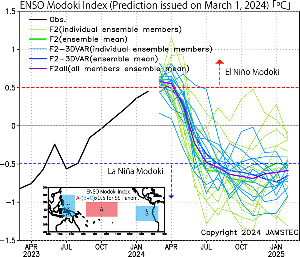
Figure 1: Monthly ENSO Modoki index (°C), which is derived from the area-averaged SST anomaly over each of the regions A (165°E-140°W, 10°S-10°N), B (110°W-70°W, 15°S-5°N), and C (125°E-145°E, 10°S-20°N), respectively. To capture the unique tripolar nature, it is calculated by A-0.5*(B+C). The black line shows the observational data of NOAA OISSTv2, and the color lines show the predictions issued on March 1, 2024, with the 24-member ensemble by the several versions of the SINTEX-F (see the SINTEX-F website for details) and the all ensemble mean (thick purple).
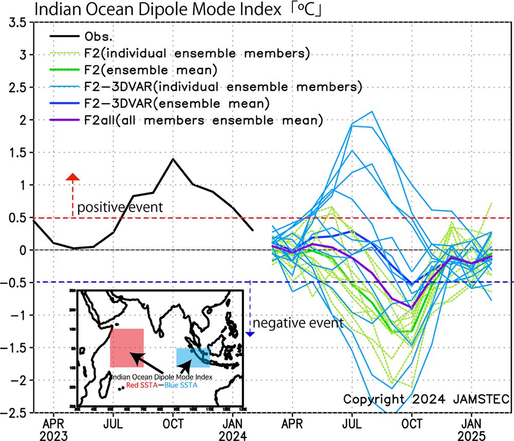
Figure 2: Same as Figure 1, but for the Indian Ocean Dipole Mode Index (DMI), which is defined as the difference of the sea surface temperature deviations from the monthly mean climatology between the western pole off East Africa (50°E–70°E, 10°S–10°N) and the eastern pole off Sumatra (90°E–110°E, 10°S–Eq).
The SINTEX-F seasonal forecasts are updated monthly. Please refer to the SINTEX-F homepage and the APL Virtualearth for the latest information.